

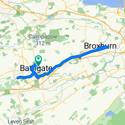
Bathgate - Edinburgh
A cycling route starting in Bathgate, Scotland, United Kingdom.
Overview
About this route
- -:--
- Duration
- 49.4 km
- Distance
- 413 m
- Ascent
- 477 m
- Descent
- ---
- Avg. speed
- 294 m
- Max. altitude
Route quality
Waytypes & surfaces along the route
Waytypes
Quiet road
15.3 km
(31 %)
Road
9.4 km
(19 %)
Surfaces
Paved
28.6 km
(58 %)
Unpaved
7.9 km
(16 %)
Asphalt
23.7 km
(48 %)
Gravel
7.9 km
(16 %)
Continue with Bikemap
Use, edit, or download this cycling route
You would like to ride Bathgate - Edinburgh or customize it for your own trip? Here is what you can do with this Bikemap route:
Free features
- Save this route as favorite or in collections
- Copy & plan your own version of this route
- Sync your route with Garmin or Wahoo
Premium features
Free trial for 3 days, or one-time payment. More about Bikemap Premium.
- Navigate this route on iOS & Android
- Export a GPX / KML file of this route
- Create your custom printout (try it for free)
- Download this route for offline navigation
Discover more Premium features.
Get Bikemap PremiumFrom our community
Other popular routes starting in Bathgate
 パー3
パー3- Distance
- 3.4 km
- Ascent
- 29 m
- Descent
- 31 m
- Location
- Bathgate, Scotland, United Kingdom
 Leyland Road 408 to Hill Place 11
- Distance
- 37.9 km
- Ascent
- 136 m
- Descent
- 266 m
- Location
- Bathgate, Scotland, United Kingdom
 6 Athol Ter, Bathgate to 4 Athol Ter, Bathgate
- Distance
- 22.7 km
- Ascent
- 127 m
- Descent
- 126 m
- Location
- Bathgate, Scotland, United Kingdom
 Leyland Road 408 to Jarvie Place 10
- Distance
- 44.6 km
- Ascent
- 191 m
- Descent
- 322 m
- Location
- Bathgate, Scotland, United Kingdom
 Bathgate to Asda Armadale to Broxburn to Bathgate 22.12.20
- Distance
- 43.5 km
- Ascent
- 249 m
- Descent
- 251 m
- Location
- Bathgate, Scotland, United Kingdom
 Slow ride in
- Distance
- 22.5 km
- Ascent
- 236 m
- Descent
- 264 m
- Location
- Bathgate, Scotland, United Kingdom
 Athol Terrace to Asda Armadale to East Mains Broxburn to Athol Terrace 24/4/21
- Distance
- 47.6 km
- Ascent
- 329 m
- Descent
- 326 m
- Location
- Bathgate, Scotland, United Kingdom
 Relaxed route in Livingston
- Distance
- 9.9 km
- Ascent
- 26 m
- Descent
- 55 m
- Location
- Bathgate, Scotland, United Kingdom
Open it in the app