

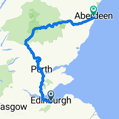
Edinburgh - Loch Levens Larder
A cycling route starting in Edinburgh, Scotland, United Kingdom.
Overview
About this route
- -:--
- Duration
- 59.8 km
- Distance
- 429 m
- Ascent
- 391 m
- Descent
- ---
- Avg. speed
- ---
- Max. altitude
Route quality
Waytypes & surfaces along the route
Waytypes
Road
14.4 km
(24 %)
Quiet road
14.4 km
(24 %)
Surfaces
Paved
43.7 km
(73 %)
Unpaved
0.6 km
(1 %)
Asphalt
41.3 km
(69 %)
Paved (undefined)
2.4 km
(4 %)
Continue with Bikemap
Use, edit, or download this cycling route
You would like to ride Edinburgh - Loch Levens Larder or customize it for your own trip? Here is what you can do with this Bikemap route:
Free features
- Save this route as favorite or in collections
- Copy & plan your own version of this route
- Sync your route with Garmin or Wahoo
Premium features
Free trial for 3 days, or one-time payment. More about Bikemap Premium.
- Navigate this route on iOS & Android
- Export a GPX / KML file of this route
- Create your custom printout (try it for free)
- Download this route for offline navigation
Discover more Premium features.
Get Bikemap PremiumFrom our community
Other popular routes starting in Edinburgh
 Dalkeith Road, Edinburgh to Leamington Walk, Edinburgh
- Distance
- 37.9 km
- Ascent
- 175 m
- Descent
- 174 m
- Location
- Edinburgh, Scotland, United Kingdom
 Leamington Terrace, Edinburgh to Leamington Terrace, Edinburgh
- Distance
- 38.6 km
- Ascent
- 423 m
- Descent
- 414 m
- Location
- Edinburgh, Scotland, United Kingdom
 Edinburgh-Rosewell Route
- Distance
- 33.4 km
- Ascent
- 331 m
- Descent
- 331 m
- Location
- Edinburgh, Scotland, United Kingdom
 westward bound circuit 07/10/17
- Distance
- 38.9 km
- Ascent
- 235 m
- Descent
- 241 m
- Location
- Edinburgh, Scotland, United Kingdom
 Edinburgh - Ormiston - Pathead - Crichton Castle - Arniston - home
- Distance
- 59.8 km
- Ascent
- 419 m
- Descent
- 419 m
- Location
- Edinburgh, Scotland, United Kingdom
 106KM Edinburgh
- Distance
- 107.1 km
- Ascent
- 532 m
- Descent
- 527 m
- Location
- Edinburgh, Scotland, United Kingdom
 waking up the mumbsculls
- Distance
- 37.5 km
- Ascent
- 208 m
- Descent
- 210 m
- Location
- Edinburgh, Scotland, United Kingdom
 High Street to Union Street
- Distance
- 303.9 km
- Ascent
- 3,256 m
- Descent
- 3,319 m
- Location
- Edinburgh, Scotland, United Kingdom
Open it in the app