
Fife
Eine Fahrradtour von Ceres, Schottland, Vereinigtes Königreich aus mit 4 Etappen.
Übersicht
Über diese Tour
Diese Radtour hat 4 Etappen und eine Gesamtlänge von 219,7 km.
- 4
- Routen
- -:--
- Dauer
- 219,7 km
- Distanz
- ---
- Ø-Tempo
- 1.624 m
- Aufstieg
- 1.625 m
- Abstieg
Nicolas Brignall

Erstellt vor 7 Jahren
Fife
Etappen dieser Tour
Alle 4 Etappen dieser Tour können auf der Karte oder in der Bikemap App für weitere Details geöffnet werden, wo du sie im Routenplaner anpassen oder als GPX- oder KML-Datei herunterladen kannst. Nutze sie als Vorlage für die Planung deiner eigenen Tour oder lass dich von Bikemap direkt entlang der Route navigieren.


Ceres - Pittenweem - Anstruther loop
Fahrradtour in Ceres, Schottland, Vereinigtes Königreich
From the car park in Ceres (cafe adjacent), uphill then a long downhill run to Pittenweem. Along the coast to Anstruther, then return by an inland route or extend by carrying on to Crail. Good road surfaces.
- 54,9 km
- Distanz
- 431 m
- Aufstieg
- 432 m
- Abstieg


Ceres - Tay shore - Tentsmuir - Leuchars
Fahrradtour in Ceres, Schottland, Vereinigtes Königreich
Start from Ceres car park (cafe adjacent) and head downhill to Cupar. Head north to Balmerino (visit the abbey) then along the coast via Newport and Tayport. Follow NCN1 through Tentsmuir gravel track) to Leuchars and return to Ceres.
- 65,4 km
- Distanz
- 445 m
- Aufstieg
- 446 m
- Abstieg

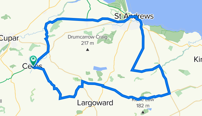
Ceres - St Andrews - Peat Inn circular
Fahrradtour in Ceres, Schottland, Vereinigtes Königreich
Starten Sie vom Parkplatz in Ceres (neben dem Café), fahren Sie nach Pitscottie und nehmen Sie die Abfahrt durch Dura Den. Vom Tal aus geht es bergauf nach Strathkinnes und St Andrews. Die Rückfahrt vermeidet Hauptstraßen, abgesehen von einer kurzen Strecke entlang der B1931. Von New Gilston gibt e…
- 46,7 km
- Distanz
- 393 m
- Aufstieg
- 392 m
- Abstieg


Ceres - Falkland - Auchtermuchty - Ladybank - Cupar
Fahrradtour in Ceres, Schottland, Vereinigtes Königreich
Starten Sie vom Parkplatz in Ceres (Café angrenzend) und fahren Sie in Richtung Chance Inn und weiter nach Südosten, bis Sie schließlich nach Westen abbiegen und aus den Hügeln hinunter zur Fahrt nach Falkland. Von dort aus über das Howe of Fife und einen kurzen Abstecher in die Hügel von Nord-Fife…
- 52,8 km
- Distanz
- 355 m
- Aufstieg
- 355 m
- Abstieg