
Radfahren in Wolverhampton
Entdecke eine Karte mit 234 Radrouten und Radwegen rund um Wolverhampton, erstellt von unserer Community.
Regionenporträt
Lerne Wolverhampton kennen
Finde die richtige Fahrradroute in Wolverhampton, wo wir 234 Fahrradrouten für dich zum Erkunden haben. Die meisten Leute fahren hier in den Monaten Mai und Juli Fahrrad.
9.624 km
Aufgezeichnete Strecken
234
Fahrradrouten
252.791
Einwohner
Community
Die aktivsten Nutzer in Wolverhampton
Von unserer Community
Die besten Fahrradrouten in und um Wolverhampton
NCR81 and South Staffs Railway Walk Route
Fahrradtour in Wolverhampton, England, Vereinigtes Königreich
Round trip route going south along canal towpath and north via the Railway Walk
- 21,9 km
- Distanz
- 61 m
- Aufstieg
- 58 m
- Abstieg
Severn Valley day ride
Fahrradtour in Wolverhampton, England, Vereinigtes Königreich
A testing ride with hilly terrain in the middle section including two ascents in excess of 1 in 7. Take note that there are not many food stops between Broseley and Arley, although the Fighting Cocks at Stottesdon can be recommended. The Church of St Mary here is also worth a visit.
- 110,1 km
- Distanz
- 606 m
- Aufstieg
- 606 m
- Abstieg
My 3rd route
Fahrradtour in Wolverhampton, England, Vereinigtes Königreich
- 47 km
- Distanz
- 0 m
- Aufstieg
- 0 m
- Abstieg
to ironbridge
Fahrradtour in Wolverhampton, England, Vereinigtes Königreich
to ironbridge
- 32,2 km
- Distanz
- 171 m
- Aufstieg
- 250 m
- Abstieg
Mehr Routen entdecken
- Wolverhampton to Bristol
- Distanz
- 347,6 km
- Aufstieg
- 1.426 m
- Abstieg
- 1.558 m
- Standort
- Wolverhampton, England, Vereinigtes Königreich
- Wolverhampton to Walsall Manor Hospital
- Distanz
- 9,5 km
- Aufstieg
- 45 m
- Abstieg
- 53 m
- Standort
- Wolverhampton, England, Vereinigtes Königreich
- Wolverhampton to Willenhall via Horsely Fields
- Distanz
- 6,4 km
- Aufstieg
- 21 m
- Abstieg
- 30 m
- Standort
- Wolverhampton, England, Vereinigtes Königreich
- work run
- Distanz
- 11,8 km
- Aufstieg
- 59 m
- Abstieg
- 61 m
- Standort
- Wolverhampton, England, Vereinigtes Königreich
- Wolverhampton to Willenhall via Strawberry Lane
- Distanz
- 6,5 km
- Aufstieg
- 15 m
- Abstieg
- 24 m
- Standort
- Wolverhampton, England, Vereinigtes Königreich
- Wolverhampton Station to Castle Ring
- Distanz
- 24,2 km
- Aufstieg
- 176 m
- Abstieg
- 97 m
- Standort
- Wolverhampton, England, Vereinigtes Königreich
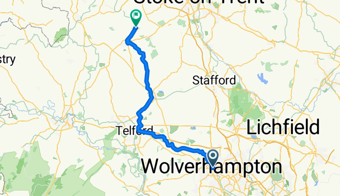
- Wolverhampton to Market Drayton
- Distanz
- 49,2 km
- Aufstieg
- 227 m
- Abstieg
- 276 m
- Standort
- Wolverhampton, England, Vereinigtes Königreich
- My first route
- Distanz
- 34,6 km
- Aufstieg
- 0 m
- Abstieg
- 0 m
- Standort
- Wolverhampton, England, Vereinigtes Königreich