
Radfahren in Wheaton
Entdecke eine Karte mit 43 Radrouten und Radwegen rund um Wheaton, erstellt von unserer Community.
Regionenporträt
Lerne Wheaton kennen
Finde die richtige Fahrradroute in Wheaton, wo wir 43 Fahrradrouten für dich zum Erkunden haben.
1.025 km
Aufgezeichnete Strecken
43
Fahrradrouten
48.284
Einwohner
Community
Die aktivsten Nutzer in Wheaton
Von unserer Community
Die besten Fahrradrouten in und um Wheaton
Wheaton to Bethesda and back
Fahrradtour in Wheaton, Maryland, USA
Wheaton - West Kensington - down Stoneybrook road (big hill).
Join Georgetown Branch trail into Bethesda.
Coming back take Branch trail to Conn.
Go 2 blocks North - join Kensington Parkway to Kensington. Home via Plyers Mill.
- 17,3 km
- Distanz
- 186 m
- Aufstieg
- 185 m
- Abstieg
Wheaton to Georgetown and back
Fahrradtour in Wheaton, Maryland, USA
Wheaton to Georgetown and back via the Capital Crescent trail through Bethesda and returning via the Rock Creek trail.
Makes use of the 2 best bike trails in DC.
- 44,6 km
- Distanz
- 273 m
- Aufstieg
- 273 m
- Abstieg
Wheaton to Friendship Heights
Fahrradtour in Wheaton, Maryland, USA
Through Kensington - down Stonybrook big hill to Rock Creek and Georgetown Branch trail.
<br />Through Bethesda - cross through Somerset town to Wisconsin.
Round trip 16 miles approx.
- 24,8 km
- Distanz
- 249 m
- Aufstieg
- 249 m
- Abstieg
Wheaton to Rockville
Fahrradtour in Wheaton, Maryland, USA
Great ride.
- 38,4 km
- Distanz
- 258 m
- Aufstieg
- 259 m
- Abstieg
Mehr Routen entdecken
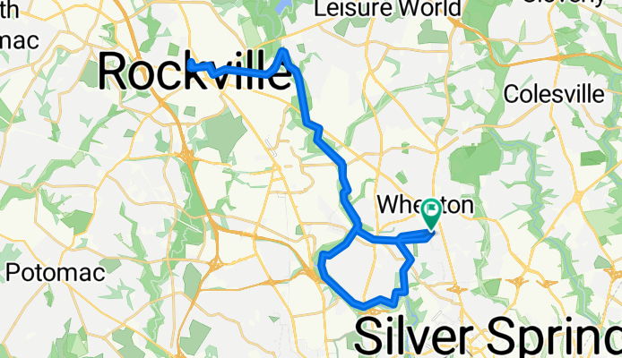
- bike tour from Silver Spring to Washington
- Distanz
- 18,1 km
- Aufstieg
- 103 m
- Abstieg
- 160 m
- Standort
- Wheaton, Maryland, USA
- Sligo Creek to Rock Creek via Takoma
- Distanz
- 25,8 km
- Aufstieg
- 197 m
- Abstieg
- 197 m
- Standort
- Wheaton, Maryland, USA
- Wheaton to Georgetown and back
- Distanz
- 44,6 km
- Aufstieg
- 245 m
- Abstieg
- 248 m
- Standort
- Wheaton, Maryland, USA
- Rock Creek to Matthew Henson trail
- Distanz
- 21,4 km
- Aufstieg
- 207 m
- Abstieg
- 204 m
- Standort
- Wheaton, Maryland, USA
- Leesburg Maryland Virginia Loop
- Distanz
- 107,2 km
- Aufstieg
- 317 m
- Abstieg
- 357 m
- Standort
- Wheaton, Maryland, USA
- Bethesda Potomac White Flint Loop
- Distanz
- 47,3 km
- Aufstieg
- 269 m
- Abstieg
- 272 m
- Standort
- Wheaton, Maryland, USA
- Wheaton to hanes Point
- Distanz
- 35,6 km
- Aufstieg
- 145 m
- Abstieg
- 255 m
- Standort
- Wheaton, Maryland, USA
- Wheaton to Olney
- Distanz
- 48,9 km
- Aufstieg
- 246 m
- Abstieg
- 247 m
- Standort
- Wheaton, Maryland, USA