
Radfahren in Mukilteo
Entdecke eine Karte mit 93 Radrouten und Radwegen rund um Mukilteo, erstellt von unserer Community.
Regionenporträt
Lerne Mukilteo kennen
Finde die richtige Fahrradroute in Mukilteo, wo wir 93 Fahrradrouten für dich zum Erkunden haben. Die meisten Leute fahren hier in den Monaten Juni und Juli Fahrrad.
3.274 km
Aufgezeichnete Strecken
93
Fahrradrouten
20.254
Einwohner
Community
Die aktivsten Nutzer in Mukilteo
Von unserer Community
Die besten Fahrradrouten in und um Mukilteo
Everett to Skagit County Line via Centennial Trail
Fahrradtour in Mukilteo, Washington, USA
Also utilizes a portion of the Interurban Trail in Everett. New connector between 204th and Downtown Arlington scheduled for completion 2013. Beware Centennial Trail congestion on weekends with nice weather. Only big hill is from Everett to Snohomish River Valley.
- 64,8 km
- Distanz
- 248 m
- Aufstieg
- 294 m
- Abstieg
Everett to LaConner
Fahrradtour in Mukilteo, Washington, USA
Good trip if you don't mind a bit of traffic here and there. A real mixed bag as far as shoulders / no shoulders, also. Have some Fudge in LaConner and forget all that. Stop at the Snow Goose Produce stand on Fir Island Rd. for fresh fruits and veggies, fire-baked pizza an
- 81,2 km
- Distanz
- 200 m
- Aufstieg
- 318 m
- Abstieg
Everett-Maple Valley 4 Trails
Fahrradtour in Mukilteo, Washington, USA
Combines three bike trails: Interurban, Burke-Gilman, Cedar River and Sammamish River. There is a two mile stretch of gravel trail N. of Issaquah but it is packed and tolerable for this short stretch. Suggest using King County Bicycle Map for portion S. of UW or else follow the
- 174,4 km
- Distanz
- 458 m
- Aufstieg
- 458 m
- Abstieg
Everett-LaConner-Whidbey Loop
Fahrradtour in Mukilteo, Washington, USA
The portion between Everett and LaConner is very flat, the rest is moderate hills. One could choose a more scenic backroad route thru Whidbey Island but it would add more miles and bigger hills. Don't miss the candy shop in LaConner. Get a good meal at the cafe in Silvana.
- 195,7 km
- Distanz
- 727 m
- Aufstieg
- 726 m
- Abstieg
Mehr Routen entdecken
- EI to Marymoor
- Distanz
- 40 km
- Aufstieg
- 115 m
- Abstieg
- 272 m
- Standort
- Mukilteo, Washington, USA
- Everett-Snohomish-Monroe-Granite Falls Tour
- Distanz
- 115,8 km
- Aufstieg
- 548 m
- Abstieg
- 544 m
- Standort
- Mukilteo, Washington, USA
- Paine Field Area Hill Ride
- Distanz
- 24,3 km
- Aufstieg
- 352 m
- Abstieg
- 349 m
- Standort
- Mukilteo, Washington, USA
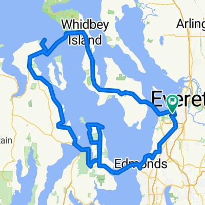
- 4 Lighthouse Century
- Distanz
- 198,8 km
- Aufstieg
- 945 m
- Abstieg
- 945 m
- Standort
- Mukilteo, Washington, USA
- Everett to Lk Washington Loop
- Distanz
- 132,8 km
- Aufstieg
- 643 m
- Abstieg
- 643 m
- Standort
- Mukilteo, Washington, USA
- Paine Field hill route.
- Distanz
- 33,7 km
- Aufstieg
- 432 m
- Abstieg
- 432 m
- Standort
- Mukilteo, Washington, USA
- Relaxed route in Mukilteo
- Distanz
- 5,7 km
- Aufstieg
- 218 m
- Abstieg
- 215 m
- Standort
- Mukilteo, Washington, USA
- try this
- Distanz
- 38,3 km
- Aufstieg
- 234 m
- Abstieg
- 284 m
- Standort
- Mukilteo, Washington, USA