


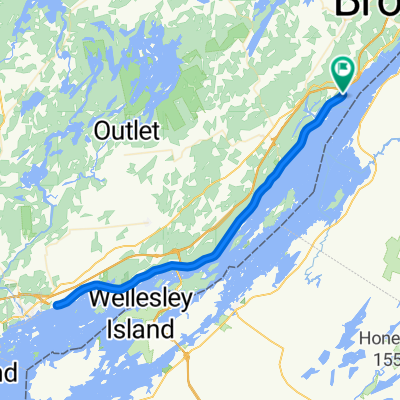
Thousand Islands Parkway
- 72,1 km
- 185 m
- 185 m
- Brockville, Ontario, Kanada
Eine Fahrradroute, die in Brockville, Ontario, Kanada beginnt.
Übersicht
Diese Route beginnt und endet in Mallorytown. Sie folgt der Cty Rd #2 mit guten asphaltierten Schultern nordöstlich bis nach Butternut Bay, dann dem Thousand Islands Parkway bis Rockport, der Escott-Rockport Road zur Cty Rd #2 und dann zurück nach Mallorytown.
In Mallorytown gibt es an der Quabbin Rd einen allgemeine Laden mit WC, Parkmöglichkeiten sind an der Straße oder im Parkplatz vorhanden.
Außerdem gibt es Einrichtungen im Browns Bay Park am Parkway (Kiosk, WC, Schwimmmöglichkeiten), ein allgemeines Geschäft in Mallorytown Landing und Restaurants in Rockport.
Die Runde kann in beide Richtungen befahren werden. Alternative Start-/Endpunkte sind Rockport, Mallorytown Landing und Browns Bay Park.
Weitere Informationen finden Sie auf der Webseite ExploreTheArch.
Erstellt vor 14 Jahren
Highlights der Route
Parking, concession, washrooms, swimming at Browns Bay Park. (vehicle entry $)
General store.
Restaurants, washrooms, gift shops, boat tours/cruises.
General store, parking, washroom.
Weiter mit Bikemap
Du möchtest Mallorytown: River and Ridges 2 (50km) fahren oder sie für deine eigene Reise anpassen? Folgendes kannst du mit dieser Bikemap-Route machen:
Kostenlose Testversion für 3 Tage oder einmalige Zahlung. Mehr über Bikemap Premium.
Entdecke weitere Premium-Funktionen.
Bikemap Premium aktivierenVon unserer Community
In der App öffnen


