Lange Laufstrecke am Sonnabend
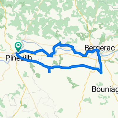
- 18,4 km
- 219 m
- 216 m
- Port-Sainte-Foy-et-Ponchapt, Nouvelle-Aquitaine, Frankreich
Eine Fahrradroute, die in Port-Sainte-Foy-et-Ponchapt, Nouvelle-Aquitaine, Frankreich beginnt.
Übersicht
Die Straßen heute waren gut, obwohl die D667 etwas zu viel Verkehr hatte ... aber nur nach den Maßstäben der französischen Landstraßen, an die wir uns schnell gewöhnt haben. Als wir weiter nach Süden kamen, wurde das allgemein hügelige Terrain, das seit unserem Start in Chadurie weiterging, steiler und schärfer, als wir die verschiedenen Flusssysteme (z.B. Dordogne, Lot usw.) überquerten.
Hintergrund: Meine Frau und ich machen seit 1993 selbstgeführte Touren in Westeuropa (meist in Frankreich). Diese Serie von Fahrten deckt unsere zweimonatige Route von 2005 durch Teile Frankreichs ab. Unser Anfangs- und Endpunkt liegt in der Nähe von Chaduri (südlich von Angoulême), wo unsere Freunde eine Farm mit Gîtes und Chambres d'Hôtes haben.
Wir fuhren unsere Dawes-Touring-Fahrräder, die wir 1993 gekauft hatten, stark beladen mit 700Cx32 Reifen. Alle unsere Fahrten fanden auf Asphaltstraßen statt, meist mit sehr wenig Verkehr.
Bei Fragen können Sie mir gerne eine E-Mail an jeffkadet@netdiving.com senden.
Jeff
Erstellt vor 14 Jahren
Highlights der Route

Hotel-Restaurant La Boule D’Or 10 Place Jean Jaurès 33220 SAINTE FOY LA GRANDE Tél : 05 57 46 00 76 / Fax : 05 57 46 12 16

Hotel-Restaurant La Boule D’Or 10 Place Jean Jaurès 33220 SAINTE FOY LA GRANDE Tél : 05 57 46 00 76 / Fax : 05 57 46 12 16 A very modest hotel that was clearly overrated at two-stars, but which at least was not overpriced at €37 for la chambre plus €5.50 each for breakfast. Even the TV was substandard with no Canal so that we couldn’t watch any of the Tour de Spain or other items. On a bicycle tour, that’s of course a relatively major issue.

HOTEL RESTAURANT LA BOULE D'OR 10 Place Jean Jaurès 33220 SAINTE FOY LA GRANDE Tél : 05 57 46 00 76 / Fax : 05 57 46 12 16 A very modest hotel that was clearly overrated at two-stars, but which at least was not overpriced at €37 for la chambre plus €5.50 each for breakfast. Even the TV was substandard with no Canal so that we couldn’t watch any of the Tour de Spain or other items. On a bicycle tour, that’s of course a relatively major issue.

Hotel-Restaurant La Boule D’Or 10 Place Jean Jaurès 33220 SAINTE FOY LA GRANDE Tél : 05 57 46 00 76 / Fax : 05 57 46 12 16 A very modest hotel that was clearly overrated at two-stars, but which at least was not overpriced at €37 for la chambre plus €5.50 each for breakfast. Even the TV was substandard with no Canal so that we couldn’t watch any of the Tour de Spain or other items. On a bicycle tour, that’s of course a relatively major issue.

Les Rives du Plantié Route de Castelmoron 47110 LE TEMPLE SUR LOT Tel. : 05 53 79 86 86 Fax : 05 53 79 86 85 accueil@rivesduplantie.com http://www.rivesduplantie.com/ A wonderful three-star Logis de France hotel. It was a little expensive by our standards, but it was just excellent in both accommodations and food.

Les Rives du Plantié Route de Castelmoron 47110 LE TEMPLE SUR LOT Tel. : 05 53 79 86 86 Fax : 05 53 79 86 85 accueil@rivesduplantie.com http://www.rivesduplantie.com/ A wonderful three-star Logis de France hotel, but a little pricey by our standards. Room and food were excellent.

Les Rives du Plantié Route de Castelmoron 47110 LE TEMPLE SUR LOT Tel. : 05 53 79 86 86 Fax : 05 53 79 86 85 accueil@rivesduplantie.com http://www.rivesduplantie.com

Les Rives du Plantié Route de Castelmoron 47110 LE TEMPLE SUR LOT Tel. : 05 53 79 86 86 Fax : 05 53 79 86 85 accueil@rivesduplantie.com http://www.rivesduplantie.com/ A wonderful three-star Logis de France hotel, but pricier than we were accustomed to.
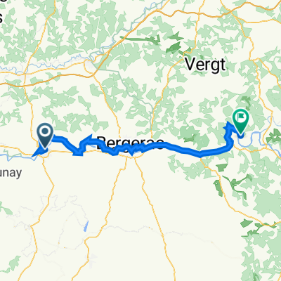
Weiter mit Bikemap
Du möchtest Ride Day 3—10 Sept 2005—33220 Ste Foy La Grande to 47110 Le Temple Sur Lot fahren oder sie für deine eigene Reise anpassen? Folgendes kannst du mit dieser Bikemap-Route machen:
Kostenlose Testversion für 3 Tage oder einmalige Zahlung. Mehr über Bikemap Premium.
Entdecke weitere Premium-Funktionen.
Bikemap Premium aktivierenVon unserer Community
In der App öffnen