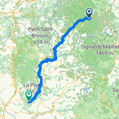
Ride Day 33—14 Oct 2005—15300 Murat to 19110 Bort-les-Orgues
Eine Fahrradroute, die in Murat, Auvergne-Rhône-Alpes, France beginnt.
Übersicht
Über diese Route
Today really felt like an easy day. After the initial climb from Murat at about 900 M to the Col d’Entremont at 1210 M, it was pretty much downhill all the way to Bort-Les-Orgues, which is something above 400 M. Getting into town, we crossed the Dordogne River.
In contrast to yesterday’s miserable weather, today’s was picture perfect with a warm and friendly sun that, along with the route, periodically had me thinking: “It can’t get any better than this”.
D16 was a perfect forest road that tracked the Santoire River. It lead us from Condat into the Gorges de la Rhue on D679 that was another perfect road. Along these roads, the fall colors were even more vivid than what we’d been seeing previously. A real pleasure.
Just before entering Bort-les-Orgues, we passed from the Cantal Department into the Corrèze Department. This meant that we also went from the Auvergne Region into the Limousin Region.
Background:My wife and I have been doing self-supported tours in Western Europe (a majority in France) since 1993. This series of rides covers our 2005 2 month route through parts of France. Our beginning and ending point is near Chaduri (south of Angoulême) where our friends have a farm with Gites and Chambres d'Hotes.We rode our Dawes touring bicycles purchased in 1993 heavily loaded with 700Cx32 tires. All of our riding was on paved roads, mostly with very little traffic.If any questions, feel free to email me at jeffkadet@netdiving.comJeff
- -:--
- Dauer
- 64,9 km
- Distanz
- 588 m
- Aufstieg
- 1.058 m
- Abstieg
- ---
- Ø-Tempo
- ---
- Ø-Tempo
Weiter mit Bikemap
Diese Radroute verwenden, bearbeiten oder herunterladen
Du möchtest Ride Day 33—14 Oct 2005—15300 Murat to 19110 Bort-les-Orgues fahren oder sie für deine eigene Reise anpassen? Folgendes kannst du mit dieser Bikemap-Route machen:
Gratis Funktionen
- Speichere diese Route als Favorit oder in einer Sammlung
- Kopiere & plane deine eigene Version dieser Route
- Synchronisiere deine Route mit Garmin oder Wahoo
Premium-Funktionen
Kostenlose Testversion für 3 Tage oder einmalige Zahlung. Mehr über Bikemap Premium.
- Navigiere diese Route auf iOS & Android
- Exportiere eine GPX / KML-Datei dieser Route
- Erstelle deinen individuellen Ausdruck (Jetzt kostenlos ausprobieren)
- Lade diese Route für die Offline-Navigation herunter
Entdecke weitere Premium-Funktionen.
Bikemap Premium aktivierenVon unserer Community
Murat: Andere beliebte Routen, die hier beginnen
- C: Lavigerie (pas de peyrol) - Saint-Vincent-de-Cosse, 3. Etappe: Genf - Bordeaux
- Distanz
- 189,6 km
- Aufstieg
- 892 m
- Abstieg
- 1.947 m
- Standort
- Murat, Auvergne-Rhône-Alpes, Frankreich
- Le Lioran (15) sur la crête sud de la vallée de la Jordanne
- Distanz
- 48,8 km
- Aufstieg
- 1.998 m
- Abstieg
- 1.997 m
- Standort
- Murat, Auvergne-Rhône-Alpes, Frankreich
- Cantal 1 - Murat
- Distanz
- 96,5 km
- Aufstieg
- 1.678 m
- Abstieg
- 1.678 m
- Standort
- Murat, Auvergne-Rhône-Alpes, Frankreich
- Genf-Bordeaux, 3.Etappe: Lavigerie P.Peyrol-Saint-Vincent-de-Cosse
- Distanz
- 190,6 km
- Aufstieg
- 784 m
- Abstieg
- 1.870 m
- Standort
- Murat, Auvergne-Rhône-Alpes, Frankreich
- France2023 E14
- Distanz
- 71,2 km
- Aufstieg
- 1.421 m
- Abstieg
- 1.644 m
- Standort
- Murat, Auvergne-Rhône-Alpes, Frankreich
- Massif Central 2009 - Tour 1 - Pässe des Cantal
- Distanz
- 128,1 km
- Aufstieg
- 2.865 m
- Abstieg
- 2.758 m
- Standort
- Murat, Auvergne-Rhône-Alpes, Frankreich
- Ride Day 33—14 Oct 2005—15300 Murat to 19110 Bort-les-Orgues
- Distanz
- 64,9 km
- Aufstieg
- 588 m
- Abstieg
- 1.058 m
- Standort
- Murat, Auvergne-Rhône-Alpes, Frankreich
- Murat to Pleaux
- Distanz
- 81,8 km
- Aufstieg
- 1.230 m
- Abstieg
- 1.487 m
- Standort
- Murat, Auvergne-Rhône-Alpes, Frankreich
In der App öffnen