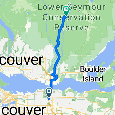
From North Vancouver to West Vancouver
- 11,9 km
- 67 m
- 82 m
- North Vancouver, British Columbia, Kanada
Eine Fahrradroute, die in North Vancouver, British Columbia, Kanada beginnt.
Übersicht
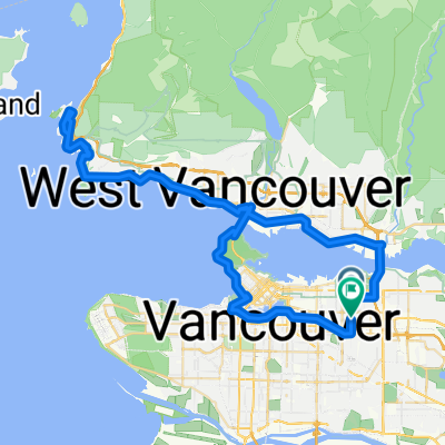
Die Fahrt von unserem AirBNB nach Hastings Street war in Ordnung, alles auf Wohnstraßen oder in Radwegen und auf Radwegen, einschließlich der Brücke über den Fluss. Hastings war jedoch größtenteils nicht optimal, da es keine Radwege und zu viel Verkehr gab. Parallelstraßen wären wahrscheinlich besser gewesen.
Das Abbiegen auf die Inlet Drive war eine Erleichterung. Diese mündete in die Barnet Road/Barnet Highway und dann in die St-Johns Street in Port Moody. Das war alles großartig. Aber nach Port Moody auf dem Barnet Highway und Lougheed Highway war der Verkehr schrecklich stark, manchmal ohne guten Straßenrand. Es wäre sinnvoll, nach parallelen Straßen zu suchen, die weniger Verkehr und weniger Straßenlärm haben könnten.
Als wir uns schließlich der Pitt River Bridge näherten, habe ich die Straßenschilder für den Radweg über die Brücke falsch gelesen. Also mussten wir wahrscheinlich ein paar zusätzliche Meilen umherfahren, um es noch einmal zu versuchen, diesmal erfolgreich. Um meinen Fehler zu vermeiden, empfehle ich, den Weg zur Brücke sehr sorgfältig zu folgen und alle Schilder zu vermeiden, die auf den Mary Hill Bypass hinweisen, von dem ich fälschlicherweise dachte, dass er uns über die Brücke führen würde.
Nach der Brücke, als wir nach Osten fuhren, waren wir auf viel besseren Straßen zum Radfahren, aber bis wir auf die Wilson Street nach Süden in Richtung Staumauer abbogen und die Straßen, die uns nach Mission führten, verlief der Verkehr durchgehend stark. Definitiv besser als der Highway 7, aber es war nicht so angenehm, wie es sein sollte. Viel zu laut. Auf die Wilson Street zu gelangen, die nach Süden zur Staumauer am Hayward Lake führt und später zur Keystone Avenue war wie ein frischer Luftzug (trotz des steilen Anstiegs beim Abbiegen auf die Keystone).
Erstellt vor 1 Jahr


Routenqualität
Radweg
13,6 km
17 %
Straße
12,8 km
16 %
Befestigt
66,3 km
(83 %)
Asphalt
59,9 km
75 %
Beton
5,6 km
7 %
Weiter mit Bikemap
Du möchtest North Vancouver to Mission fahren oder sie für deine eigene Reise anpassen? Folgendes kannst du mit dieser Bikemap-Route machen:
Kostenlose Testversion für 3 Tage oder einmalige Zahlung. Mehr über Bikemap Premium.
Entdecke weitere Premium-Funktionen.
Bikemap Premium aktivierenVon unserer Community
In der App öffnen