Dag 13 Haugen
- 80,9 km
- 546 m
- 633 m
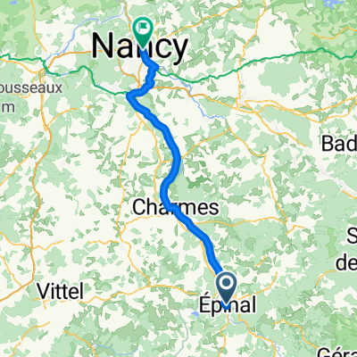
- Épinal, Grand Est, Frankreich
Eine Fahrradroute, die in Épinal, Grand Est, Frankreich beginnt.
Übersicht
Wunderschöne Straße, aber schrecklich für Fahrräder, da der Verkehr relativ stark war und es keine Schultern gab. Die einzige Ausnahme war D417 in Gérardmer und Xonrupt-Longemer, wo es einen guten Radweg gab, um mit dem gesamten Verkehr umzugehen. Die meisten von dieser kurzen Zickzackfahrt waren leicht steigende 300 oder 400 Meter bis etwa 700 Meter an unserem Hotel. Wir hatten bemerkt, dass dieser Abschnitt des Nordostens in den letzten Tagen und heute relativ wohlhabender zu sein scheint als die meisten anderen Teile Frankreichs, durch die wir auf dieser Reise gefahren sind. Besonders gestern sahen wir viele Neubauten und einige im Boden eingelassene Pools. Heute, während wir entlang der D417 fuhren, gab es viele Bauunternehmen, die Musterhäuser errichtet hatten, damit die Leute sie für ihre eigenen Grundstücke kaufen konnten. Diese Fahrt fand vollständig im Département Vosges der Region Lothringen statt. Hintergrund: Meine Frau und ich machen seit 1993 selbstgeführte Touren in westeuropäischen Ländern (mehrheitlich in Frankreich). Diese Serie von Fahrten deckt unsere 4,5-monatige Route von 2009 durch Teile Frankreichs, Deutschlands, Österreichs, der Schweiz und dann zurück nach Frankreich ab. Unser Start- und Endpunkt ist in der Nähe von Chadurie (südlich von Angoulême), wo unsere Freunde eine Farm mit Gîtes und Chambres d'Hôtes haben. Wir fuhren unsere Dawes-Tourenräder, die wir 1993 gekauft hatten, stark beladen mit 700Cx32 Reifen. Alle unsere Fahrten fanden auf gepflasterten Straßen statt, hauptsächlich mit sehr wenig Verkehr. So gut wie die einzigen unbefestigten Abschnitte waren einige Radwege in Deutschland und Österreich. Leider war das nicht so großartig, da Helen mehrmals auf den unbefestigten Wegen gefallen ist. Glücklicherweise jedoch keine ernsthaften Verletzungen. Bei Fragen können Sie mir gerne eine E-Mail an jeffkadet@netdiving.com senden. Jeff
Erstellt vor 13 Jahren
Routenqualität
Ruhige Straße
4,4 km
9 %
Straße
1,5 km
3 %
Befestigt
34,7 km
(71 %)
Asphalt
34,7 km
71 %
Undefiniert
14,2 km
29 %
Weiter mit Bikemap
Du möchtest 2009 Euro Tour -- Ride Day 30 — 29 July 2009 — 88000 Epinal to 88400 Xonrupt-Longemer fahren oder sie für deine eigene Reise anpassen? Folgendes kannst du mit dieser Bikemap-Route machen:
Kostenlose Testversion für 3 Tage oder einmalige Zahlung. Mehr über Bikemap Premium.
Entdecke weitere Premium-Funktionen.
Bikemap Premium aktivierenVon unserer Community
In der App öffnen