- 32 km
- 69 m
- 67 m
- Sainte-Anne-de-Bellevue, Québec, Kanada
04 Aug 2012 Châteauguay valley +
Eine Fahrradroute, die in Sainte-Anne-de-Bellevue, Québec, Kanada beginnt.Tagestour am 4. August 2012Die Gesamtlänge der tatsächlichen Tour betrug wahrscheinlich etwa 138 km (etwa 86 Meilen), da etwa 10 km eine Fährfahrt von Lachine nach Châteauguay waren und das Trampen über die Brücke nach Valleyfield etwa 2 km umfasste.
Insgesamt ziemlich flach.
- -:--
- Dauer
- 150,1 km
- Distanz
- 88 m
- Aufstieg
- 88 m
- Abstieg
- ---
- Ø-Tempo
- ---
- Max. Höhe
Interessanter Ort nach 27 km
Interessanter Ort nach 52,3 km
Interessanter Ort nach 55 km
Start of gravel bike path, on old railroad grade
Interessanter Ort nach 56,2 km
Bike trail as of today has an overpass built over future Auroroute 30, but it is closed to traffic, the trail crosses the 30 at ground level, which is fine for now since the highway hasn't been opened yet, but unless one has a mountain bike one has to walk the bike maybe 50 m (150-200 ft)
Interessanter Ort nach 61,4 km
Bike path now paved
Interessanter Ort nach 63,7 km
Oops, went the wrong way and had to come back, trail directions poorly indicated.
Interessanter Ort nach 66,8 km
Bike path continues paved
Interessanter Ort nach 103,7 km
Bridge cannot be crossed on a bicycle, hitchhiked across
Interessanter Ort nach 105,7 km
Dropped off here, 17:20
Interessanter Ort nach 128,2 km
Former source of cold water, no longer functional
Interessanter Ort nach 131,9 km
Construction over a short distance, walk with road bike, probably passable with hybrid or mountain bike.
Interessanter Ort nach 150,1 km
Departure, 09:00
Interessanter Ort nach 150,1 km
Finish ~20:45
- Speichere diese Route als Favorit oder in einer Sammlung
- Kopiere & plane deine eigene Version dieser Route
- Teile sie in Etappen ein, um eine mehrtägige Tour zu erstellen
- Synchronisiere deine Route mit Garmin oder Wahoo
Kostenlose Testversion für 3 Tage oder einmalige Zahlung. Mehr über Bikemap Premium.
- Navigiere diese Route auf iOS & Android
- Exportiere eine GPX / KML-Datei dieser Route
- Erstelle deinen individuellen Ausdruck (Jetzt kostenlos ausprobieren)
- Lade diese Route für die Offline-Navigation herunter
Entdecke weitere Premium-Funktionen.
Bikemap Premium aktivieren- 
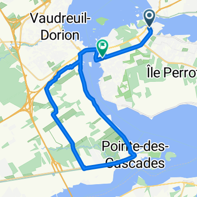
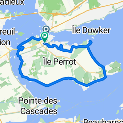
Grand Blvd, L'Île-Perrot to Grand Blvd, L'Île-Perrot
- Ste. Anne de Bellevue-Les Cedres
- 45,3 km
- 38 m
- 40 m
- Sainte-Anne-de-Bellevue, Québec, Kanada
- 9 June 2020 - Pointe Fortune - Mando
- 108,4 km
- 225 m
- 222 m
- Sainte-Anne-de-Bellevue, Québec, Kanada
- 222 Rue Sainte-Anne, Sainte-Anne-de-Bellevue to 186 Rue Sainte-Anne, Sainte-Anne-de-Bellevue
- 24,5 km
- 91 m
- 99 m
- Sainte-Anne-de-Bellevue, Québec, Kanada
- August 2011 trip
- 473,2 km
- 238 m
- 238 m
- Sainte-Anne-de-Bellevue, Québec, Kanada
- From L'Île-Perrot to Pincourt
- 26,9 km
- 62 m
- 61 m
- Sainte-Anne-de-Bellevue, Québec, Kanada
- 186 Rue Sainte-Anne, Sainte-Anne-de-Bellevue to 186 Rue Sainte-Anne, Sainte-Anne-de-Bellevue
- 73,1 km
- 41 m
- 48 m
- Sainte-Anne-de-Bellevue, Québec, Kanada
- 167 Rue Sainte-Anne, Sainte-Anne-de-Bellevue to 167 Rue Sainte-Anne, Sainte-Anne-de-Bellevue
- 24 km
- 58 m
- 59 m
- Sainte-Anne-de-Bellevue, Québec, Kanada
In der App öffnen


