Route in Santa Fe
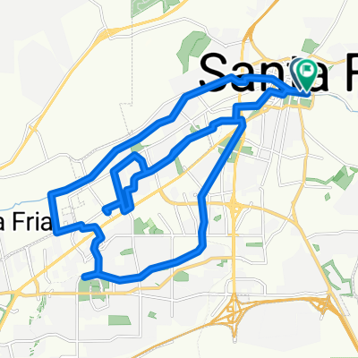
- 1,9 km
- 19 m
- 7 m
- Santa Fe, New Mexico, Vereinigte Staaten
Eine Fahrradroute, die in Santa Fe, New Mexico, Vereinigte Staaten beginnt.
Übersicht
The route follows the still operational Santa Fe Southern Line from Santa Fe Depot to Lamy Depot. The trail has three portions: the potion within the Santa Fe City Limits is paved and well populated by bikes, joggers and pedestrians. Leaving the southern city limit at Rabbit Road, the bike trail is dirt, but has been recently re-graded and hard packed for about 2 miles. At that point it joins onto a gravel trail heading west to the commmunity college where you can return to the city if you like a shorter route. Venturing further south, though, the trail is rough. Care in riding is required here as the trail goes through some deep sand traps that can toss you over the handlebars (personal experience with this). It's not dangerous if you take it slow and keep you eye on what's ahead. No road bikes can pass through this section, but its fine with a dirt or other fat-tire bike. Return by the same route, or on the roads from Lamy, via US 285.
Erstellt vor 13 Jahren
Weiter mit Bikemap
Du möchtest Rail Trail fahren oder sie für deine eigene Reise anpassen? Folgendes kannst du mit dieser Bikemap-Route machen:
Kostenlose Testversion für 3 Tage oder einmalige Zahlung. Mehr über Bikemap Premium.
Entdecke weitere Premium-Funktionen.
Bikemap Premium aktivierenVon unserer Community
In der App öffnen