


Leon Marshall Wall and Wilson Hill
Eine Fahrradroute, die in Inverness, Kalifornien, Vereinigte Staaten beginnt.
Übersicht
Über diese Route
0
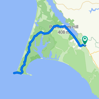
Dies ist die Tour von Leon Sun. Er wird am 20. eine Tour durch West Marin leiten. Gegen Ende der Tour möchte ich am G.R.O. Art Gallery in Pt Reyes Station anhalten, wo mein Freund Lucien Kubo eine Einzelausstellung hat. Hier sind die Einzelheiten der Tour, falls du sie posten möchtest: Start: 9:00 Uhr, Bear Valley Visitor Center, Bear Valley Rd, Olema. Route: Verlassen des Besucherzentrums, rechts auf Bear Valley Rd, links (nördlich) auf Hwy 1, rechts auf Marshall-Petaluma Rd (Marshall Wall, etwa 1100 ft Höhengewinn), links auf Wilson Hill Rd, links auf Chileno Valley Rd, links auf Tomales-Petaluma Rd, rechts auf Hwy 1 nach Tomales, Halt für Mittagessen oder Snack, Rückfahrt nach Süden auf Hwy 1 bis Bear Valley Rd, rechts abbiegen, links in das Besucherzentrum. Marshall Wall und Wilson Hill sind die beiden Hauptanstiege, insgesamt etwa 1500 ft Höhenunterschied. Der Rest sind Rollen. Insgesamt etwa 60 Meilen, Gesamtdistanz. Überlappt Teile der Pilgerroute. Anhalten in der Galerie ist natürlich optional.
- -:--
- Dauer
- 98,3 km
- Distanz
- 1.271 m
- Aufstieg
- 1.276 m
- Abstieg
- ---
- Ø-Tempo
- 220 m
- Max. Höhe
berkeley_rinaldi
Erstellt vor 16 Jahren
Routenqualität
Wegtypen und Untergründe entlang der Route
Wegtypen
Straße
20,6 km
21 %
Ruhige Straße
1 km
1 %
Undefiniert
76,7 km
78 %
Untergründe
Befestigt
44,2 km
(45 %)
Asphalt
44,2 km
45 %
Undefiniert
54,1 km
55 %
Highlights der Route
POIs entlang der Route
Interessanter Ort nach 20,3 km
R Marshall-Petaluma Rod (Marshall Wall about 1100' elev gain)
Interessanter Ort nach 42,4 km
L Chileno Valley Rd
Interessanter Ort nach 53,4 km
R Chileno Valley Rd
Interessanter Ort nach 58,1 km
L Tomales Petaluma Rd.
Interessanter Ort nach 67,1 km
Interessanter Ort nach 67,8 km
LUNCH IN TOMALES
Interessanter Ort nach 68,4 km
L Shoreline HWY1
Weiter mit Bikemap
Diese Radroute verwenden, bearbeiten oder herunterladen
Du möchtest Leon Marshall Wall and Wilson Hill fahren oder sie für deine eigene Reise anpassen? Folgendes kannst du mit dieser Bikemap-Route machen:
Gratis Funktionen
- Speichere diese Route als Favorit oder in einer Sammlung
- Kopiere & plane deine eigene Version dieser Route
- Teile sie in Etappen ein, um eine mehrtägige Tour zu erstellen
- Synchronisiere deine Route mit Garmin oder Wahoo
Premium-Funktionen
Kostenlose Testversion für 3 Tage oder einmalige Zahlung. Mehr über Bikemap Premium.
- Navigiere diese Route auf iOS & Android
- Exportiere eine GPX / KML-Datei dieser Route
- Erstelle deinen individuellen Ausdruck (Jetzt kostenlos ausprobieren)
- Lade diese Route für die Offline-Navigation herunter
Entdecke weitere Premium-Funktionen.
Bikemap Premium aktivierenVon unserer Community
Inverness: Andere beliebte Routen, die hier beginnen


 Point reyes station to point out and back2
- 63,7 km
- 714 m
- 714 m
- Inverness, Kalifornien, Vereinigte Staaten


In der App öffnen