0
- 56,9 km
- 662 m
- 716 m
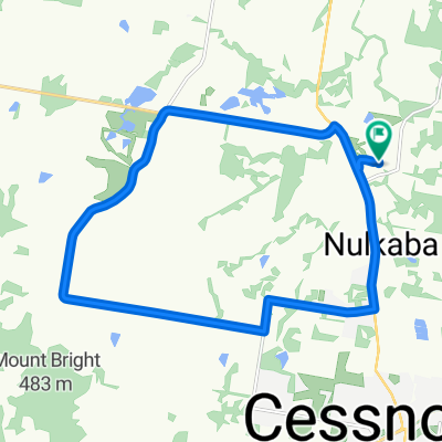
- Cessnock, New South Wales, Australien
Eine Fahrradroute, die in Cessnock, New South Wales, Australien beginnt.
Übersicht
Large sections of this route are either gravel road or sandy / rocky fire trail. A mountainbike is required.
The first half is the most picturesque and the most hilly. It travels through green rolling hills and wineries The return leg is through the sandy scrub of "powerline road" and the towns of Ellalong and Paxton. This ride took me 4 hours to complete. (cloned from route 359002)Erstellt vor 10 Jahren
Routenqualität
Ruhige Straße
22,7 km
43 %
Straße
18,5 km
35 %
Befestigt
34,9 km
(66 %)
Unbefestigt
15,8 km
(30 %)
Asphalt
31,2 km
59 %
Unbefestigt (undefiniert)
15,8 km
30 %
Highlights der Route
The next section is very sandy
Don't get lost here. If in doubt, follow the powerline
Weiter mit Bikemap
Du möchtest Millfield to Cessnock loop fahren oder sie für deine eigene Reise anpassen? Folgendes kannst du mit dieser Bikemap-Route machen:
Kostenlose Testversion für 3 Tage oder einmalige Zahlung. Mehr über Bikemap Premium.
Entdecke weitere Premium-Funktionen.
Bikemap Premium aktivierenVon unserer Community
In der App öffnen