0
- 27,2 km
- 268 m
- 245 m
- Matthews, North Carolina, Vereinigte Staaten
Eine Fahrradroute, die in Matthews, North Carolina, Vereinigte Staaten beginnt.
Übersicht
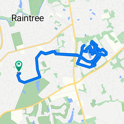
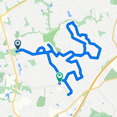
Diese Runde führt fast ausschließlich über Wohnstraßen, daher ist sie ideal für Familien. Allerdings muss man ein paar Straßen ohne Fußgängerüberweg überqueren. Das ist durchaus machbar, nur vielleicht nicht zur Hauptverkehrszeit [über die Fairview kommst du nie rüber]. Es gibt ein paar kurze, steile Anstiege, aber keine wirklichen Klettereien. Auf dem McAlpine Greenway sind etwa 1,5 Kilometer Schotter-/Wegstrecke. Ich fahre das auf meinem Rennrad mit 25c Reifen und komme damit gut klar. Man muss nur vernünftig fahren und in den Kurven vorsichtig sein, wenn man mit einem Rennrad auf losem Schotter unterwegs ist. Natürlich ist es eine Runde, daher kann der Start/Zielpunkt überall liegen. Wenn du nicht entlang der Strecke wohnst, kannst du am McAlpine Greenway Park an der Monroe Road parken und dort starten.
Erstellt vor 9 Jahren
Routenqualität
Ruhige Straße
25,3 km
67 %
Radweg
6,8 km
18 %
Befestigt
10,2 km
(27 %)
Unbefestigt
1,1 km
(3 %)
Asphalt
6,8 km
18 %
Beton
3,4 km
9 %
Weiter mit Bikemap
Du möchtest Tour de South-East Charlotte 25 mile loop fahren oder sie für deine eigene Reise anpassen? Folgendes kannst du mit dieser Bikemap-Route machen:
Kostenlose Testversion für 3 Tage oder einmalige Zahlung. Mehr über Bikemap Premium.
Entdecke weitere Premium-Funktionen.
Bikemap Premium aktivierenVon unserer Community
In der App öffnen