Lotte Market Trip
- 21,5 km
- 126 m
- 121 m
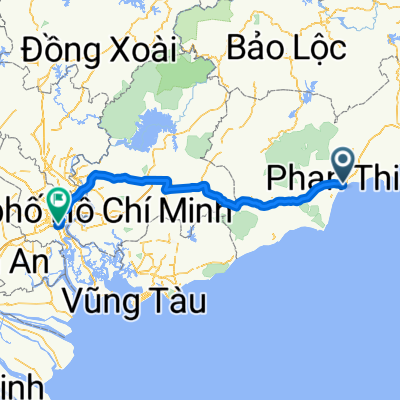
- Phan Thiết, Bình Thuận, Vietnam
Mui Ne Challenge
Eine Fahrradroute, die in Phan Thiết, Bình Thuận, Vietnam beginnt.
Übersicht
Rückfahrt, Abfahrt um 7 Uhr, weniger Pausen, um vor Sonnenuntergang anzukommen, und es wurde 17:30 gerade rechtzeitig erreicht. Gemischte Winde, aber mehr von der Seite, Umleitung nach Ho Tram (es hat sich gelohnt) und die langen geraden Straßen sind gut, weil es keine Ampeln gibt, aber es geht rauf und runter. Schließlich 250 km in 10,5 Stunden, Höhenunterschied mit all den Anstiegen und Abstiegen 2000 m (das sagt mein GPS) = 28,9 km/h Durchschnitt.
Erstellt vor 9 Jahren
Teil von
Mui Ne Challenge
2 Etappen
Highlights der Route

Demolished old resort, picturesque place

Rock Water Bay resort

2 wheel bridge

Marvellous beach, but full with trash

idyllic Vietnam

Cafe Thuy Saigon Rest :)

Yeah first sights of Saigon at 5 PM on Cat Lai ferry
Weiter mit Bikemap
Du möchtest Mui Ne Challenge Day 2 return fahren oder sie für deine eigene Reise anpassen? Folgendes kannst du mit dieser Bikemap-Route machen:
Kostenlose Testversion für 3 Tage oder einmalige Zahlung. Mehr über Bikemap Premium.
Entdecke weitere Premium-Funktionen.
Bikemap Premium aktivierenVon unserer Community
In der App öffnen