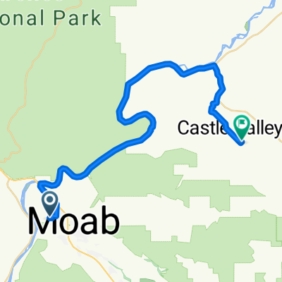
Moab Up SR128 and Along La Sal Loop Rd
Eine Fahrradroute, die in Moab, Utah, Vereinigte Staaten beginnt.
Übersicht
Über diese Route
This was a terrific ride with wonderful scenery. The ride along the Colorado has excellent scenery. There's a couple of miles of bike path, but most of the ride along the river is on a two lane road with no shoulder. This wasn't a problem as the traffic was fairly light. However, we can imagine that the traffic would be heavier in the tourist season.
Along La Sal Loop Rd, it was perfect riding with virtually zero traffic and wonderful scenery. Due to my wife's having some back pain plus a sign saying that the road was closed ahead, we didn't do the bigger circle we'd hoped to do and simply retraced our steps back to our starting place in Moab. We hope to return someday to do the full circle.
- -:--
- Dauer
- 74,5 km
- Distanz
- 615 m
- Aufstieg
- 609 m
- Abstieg
- ---
- Ø-Tempo
- ---
- Max. Höhe
Fotos von der Route
Routenqualität
Wegtypen und Untergründe entlang der Route
Wegtypen
Radweg
11,2 km
(15 %)
Ruhige Straße
0,7 km
(1 %)
Untergründe
Befestigt
73,7 km
(99 %)
Asphalt
53,6 km
(72 %)
Befestigt (undefiniert)
19,4 km
(26 %)
Weiter mit Bikemap
Diese Radroute verwenden, bearbeiten oder herunterladen
Du möchtest Moab Up SR128 and Along La Sal Loop Rd fahren oder sie für deine eigene Reise anpassen? Folgendes kannst du mit dieser Bikemap-Route machen:
Gratis Funktionen
- Speichere diese Route als Favorit oder in einer Sammlung
- Kopiere & plane deine eigene Version dieser Route
- Synchronisiere deine Route mit Garmin oder Wahoo
Premium-Funktionen
Kostenlose Testversion für 3 Tage oder einmalige Zahlung. Mehr über Bikemap Premium.
- Navigiere diese Route auf iOS & Android
- Exportiere eine GPX / KML-Datei dieser Route
- Erstelle deinen individuellen Ausdruck (Jetzt kostenlos ausprobieren)
- Lade diese Route für die Offline-Navigation herunter
Entdecke weitere Premium-Funktionen.
Bikemap Premium aktivierenVon unserer Community
Moab: Andere beliebte Routen, die hier beginnen
 Porcupine Rim Trail
- Distanz
- 22,9 km
- Aufstieg
- 529 m
- Abstieg
- 1.054 m
- Standort
- Moab, Utah, Vereinigte Staaten
 Route in Moab
- Distanz
- 37 km
- Aufstieg
- 988 m
- Abstieg
- 741 m
- Standort
- Moab, Utah, Vereinigte Staaten
 Moab - Runde
- Distanz
- 76,8 km
- Aufstieg
- 1.470 m
- Abstieg
- 1.484 m
- Standort
- Moab, Utah, Vereinigte Staaten
 Moab - A Pretty Flat Route to Potash
- Distanz
- 66,2 km
- Aufstieg
- 1.097 m
- Abstieg
- 1.092 m
- Standort
- Moab, Utah, Vereinigte Staaten
 Portal Long Canyon Mag7 Portal
- Distanz
- 72,7 km
- Aufstieg
- 1.754 m
- Abstieg
- 1.750 m
- Standort
- Moab, Utah, Vereinigte Staaten
 Moab
Moab- Distanz
- 17,3 km
- Aufstieg
- 691 m
- Abstieg
- 708 m
- Standort
- Moab, Utah, Vereinigte Staaten
 Salt Wash-DAV
- Distanz
- 11,9 km
- Aufstieg
- 469 m
- Abstieg
- 356 m
- Standort
- Moab, Utah, Vereinigte Staaten
 Dead Horse Point Outside Loop
- Distanz
- 25 km
- Aufstieg
- 776 m
- Abstieg
- 774 m
- Standort
- Moab, Utah, Vereinigte Staaten
In der App öffnen


