rif. Teodulo - Furi - Gornergrat - Gruensee
- 28,4 km
- 1.420 m
- 2.420 m
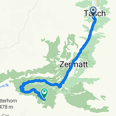
- Zermatt, Kanton Wallis, Schweiz
Eine Fahrradroute, die in Zermatt, Kanton Wallis, Schweiz beginnt.
Übersicht
Partenza da Tasch, single track in salita per Zermatt poi asfalto fino a dopo Furi poi sterrata a tratti duri fino allo Schwarzsee. - Discesa bellissima! a tratti abbastanza tecnica ma mai estrema.
ritorno a Tasch per lo stesso single-track.
The adventure begins at the valley station of Matterhorn glacier paradise, where riders comfortably load their bikes onto the gondolas. Even on the ride up, the gondola offers lovely, ever-changing views of the Matterhorn. There’s plenty more to see, too: who will be the first to spot a marmot or chamois – or, in autumn, even a herd of ibex?
At Schwarzsee it’s worth stopping for a coffee, to enjoy the view of the Matterhorn and the Schwarzsee lake. Perhaps even call in to the little chapel, “Maria zum Schnee”, on the lakeshore. And then it’s time to set off: a ride of about two kilometres along mountain trails, past meadows full of alpine flowers and grazing cows, with views of the Weisshorn, Mischabel massif and the upper Matter valley. Next come a good 2.5 kilometres on gravel trails and then finally mountain lanes: a wonderfully leisurely ride, downhill all the way.
Allow plenty of time to enjoy the sights en route. This bike trail promises a wide variety of attractions – starting with impressive views of the Matterhorn, with ever-changing perspectives. The north face seems to come ever closer, its dark, majestic and intimidating cliffs soaring 1,000 metres vertically into the sky. Below it lies the white Matterhorn Glacier, riven with crevasses.
Erstellt vor 8 Jahren
Weiter mit Bikemap
Du möchtest Tasch - Zermatt - Schwarzsee fahren oder sie für deine eigene Reise anpassen? Folgendes kannst du mit dieser Bikemap-Route machen:
Kostenlose Testversion für 3 Tage oder einmalige Zahlung. Mehr über Bikemap Premium.
Entdecke weitere Premium-Funktionen.
Bikemap Premium aktivierenVon unserer Community
In der App öffnen