Forster to Mungo Brush
- 65,6 km
- 312 m
- 309 m
- Forster, New South Wales, Australien
Eine Fahrradroute, die in Forster, New South Wales, Australien beginnt.
Übersicht
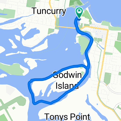
Südlich von Forster ist die Lakes Way viel ruhiger. Sie ist auch komplett flach bis zum Booti Booti NP und hat einen Schulter, wenn auch ziemlich schmal, die meiste Zeit bis nach Bungwahl. Dort bogen wir auf die Straße nach Seal Rocks ab und dann in den Myall Lakes National Park. Der gut erhaltene NP-Verwaltungspfad ist eine bezaubernde Fahrt, da er flach, gut gepflegt und für den allgemeinen Verkehr gesperrt ist. Die einzigen Fahrzeuge, die wir trafen, waren von den National Parks oder anderen Radfahrern. Der Old Gibber Trail trennt sich etwa 11 km von der alten Bergbaustraße. Es ist wichtig, dem Gibber Trail zu folgen, da die alternative Straße bis zu ihrer Kreuzung mit der Hawks Nest Rd nicht gewartet wird und viele Radfahrer, die den falschen Weg genommen haben, mit Sand und einem überwucherten Weg zu kämpfen hatten. Wenn man diese Route in umgekehrter Richtung fährt, ist es wichtig, auf der Mungo Brush Rd zu bleiben, bis man den Boomeri-Campingplatz erreicht.
Erstellt vor 7 Jahren


Routenqualität
Forst- / Feldweg
21 km
32 %
Ruhige Straße
16,4 km
25 %
Befestigt
40,7 km
(62 %)
Unbefestigt
19,7 km
(30 %)
Asphalt
40,7 km
62 %
Schotter
17 km
26 %
Weiter mit Bikemap
Du möchtest Forster to Mungo Brush fahren oder sie für deine eigene Reise anpassen? Folgendes kannst du mit dieser Bikemap-Route machen:
Kostenlose Testversion für 3 Tage oder einmalige Zahlung. Mehr über Bikemap Premium.
Entdecke weitere Premium-Funktionen.
Bikemap Premium aktivierenVon unserer Community
In der App öffnen