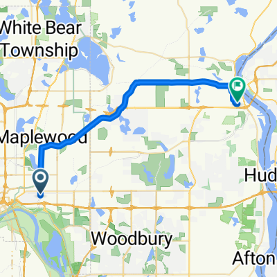
B2B00211 55119>55101 via Upper Afton, 7th Street
- 17,8 km
- 189 m
- 192 m
- Maplewood, Minnesota, Vereinigte Staaten
Eine Fahrradroute, die in Maplewood, Minnesota, Vereinigte Staaten beginnt.
Übersicht
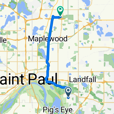
Nehmen Sie den Johnson Pkwy nach Norden bis zum Lake Phalen, wo er zum Wheelock Pkwy wird. Folgen Sie dem Wheelock Pkwy über die 35E und die Rice Street. Nach der Rice Street gibt es einen großen, kurvenreichen Hügel. Fahren Sie weiter auf dem Wheelock, bis Sie den Lake Como erreichen. Biegen Sie am Como nach links ab und fahren Sie um den See bis zur W. Horton Av. Folgen Sie der Horton bis zum Lexington Pkwy. Fahren Sie geradeaus, während die Straße an der Hamiline zur Como Avenue wird. Fahren Sie weiter auf der Como Avenue vorbei an den State Fair Grounds, bis Sie den Intercampus Trailway erreichen. Biegen Sie links in den Trailway ab und fahren Sie über die Brücke in der Straße. An der Energy Park Drive können Sie entweder auf der Straße bleiben oder auf dem Radweg fahren. Fahren Sie weiter, bis Sie die 29th AvSE erreichen. Biegen Sie links in die nächste Straße zur 4th St.SE ab. Biegen Sie rechts auf die 4th St. zur 27th AvSE ab. Biegen Sie links ab und fahren Sie auf der 27th AvSE über die University Av. bis zur Franklin Bridge. Überqueren Sie die Franklin Bridge und folgen Sie der Franklin Av. bis zur Riverside Av. Biegen Sie rechts in die Riverside ab. Biegen Sie nach der Überquerung der I94 links in die Butler Pl. ab. Folgen Sie der Butler Place bis zur 23rd Av. S und biegen Sie rechts zum Augsburg College ab.
Routenqualität
Straße
11,8 km
62 %
Radweg
4,8 km
25 %
Befestigt
12,6 km
(66 %)
Asphalt
11,5 km
60 %
Beton
0,8 km
4 %
Weiter mit Bikemap
Du möchtest B2B00401 55106>55454 via WheelockPkwy/Como/IntercampusTrail/27SE/Franklin/Riverside fahren oder sie für deine eigene Reise anpassen? Folgendes kannst du mit dieser Bikemap-Route machen:
Kostenlose Testversion für 3 Tage oder einmalige Zahlung. Mehr über Bikemap Premium.
Entdecke weitere Premium-Funktionen.
Bikemap Premium aktivierenVon unserer Community
In der App öffnen