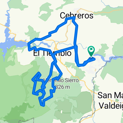
CABAÑA CERROGUISANDO AL POZO DE LA NIEVE
Eine Fahrradroute, die in El Tiemblo, Nordkastilien, Spanien beginnt.
Übersicht
Über diese Route
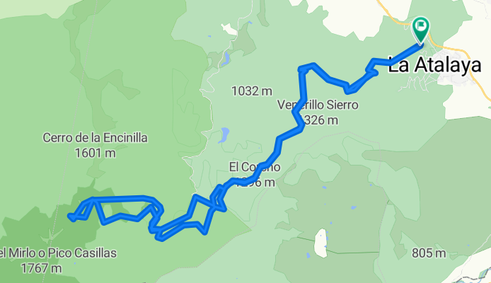
Route for both MTB and hiking starting from the Rural Cabin Cerroguisando, 1 hour from Madrid, in the province of Ávila, where you can park vehicles inside, prepare the bikes, whether you are staying there or not, for free. Call to notify: +34 675 453 139 www.cerroguisando.es
MTB: 2h30 medium pace, stopping when necessary.
- The difficulty for MTB are the 3 steep climbs of about 50m that we find in 3 main points:
-
the slope at the beginning (10min of suffering and climbing techniques with water channels and loose stones)
-
Climb from the recreational area 'Las Barrancas' to the intermediate meadow (Vaquerizas) about 15min of trail among sticks and pine cones fairly steep.
-
Last 300m of loose stone before the gate of the well (15min tough both for ramp and for the terrain)
- On the way back, taking off 10 min of ascent 7% or 10% of wide GR in 'El Castañar' that can be climbed perfectly, the only additional difficulty on the way back is TO KEEP the arms and wrists due to the tremendous descent time back to our Cabin Cerroguisando.
HIKING:
- The only difficulty we find is the DURATION of the route, since the slopes you can read in the MTB route description, on foot are only of medium difficulty, neither hard nor steep nor long to go with trail or trekking shoes.
WATER POINTS.
There are water points at km 5 and 7 on the way there and just before facing the last slopes, both in the recreational area of las Barrancas, and just before the last steep slope.
75% of the route runs along GR and 4m wide sandy road.
SEASONS: ALL (There is a lot of shade)
RECOMMENDED: MAY TO JUNE - OCTOBER TO NOVEMBER.
- -:--
- Dauer
- 23,8 km
- Distanz
- 826 m
- Aufstieg
- 832 m
- Abstieg
- ---
- Ø-Tempo
- ---
- Max. Höhe
Highlights der Route
POIs entlang der Route
Trinkwasser nach 4,1 km
FUENTE: todo el año, rara vez en verano esta sin agua. No potabilizada.
Trinkwasser nach 5 km
fuente que puede estar sin servicio en verano.
Interessanter Ort nach 7,3 km
ARBOL CON PIERNAS...foto mágica!!
Interessanter Ort nach 9,6 km
AREA RECREATIVA DE LAS BARRANCAS. AGUA, MERENDERO Y PARKING.
Trinkwasser nach 10,4 km
última fuente antes del ascenso mas intenso, si vas a pernoctar en el pozo de la nieve, este es el último punto de agua canalizada. no potabilizada y con agua todo el año
Unterkunft nach 12,1 km
PARA PERNOCTAR EN CASO DE NECESIDAD. Es amplio, caben unas 20 personas o 5 a 10 con bicicletas. No tiene goteras y se agradece tambien que apenas entra aire. IMPORTANTE: Los fines de semana a las 9:00 de la mañana ya suele entrar gente que esta haciendo la excursion para conocer el pozo de la nieve. Por las noches hasta en verano 10ºc a 15ºc grados, en otoño se duerme entre 0º c y 5ºc y en invierno....0ºc...es alta montaña..PRECAUCIÓN !!
Weiter mit Bikemap
Diese Radroute verwenden, bearbeiten oder herunterladen
Du möchtest CABAÑA CERROGUISANDO AL POZO DE LA NIEVE fahren oder sie für deine eigene Reise anpassen? Folgendes kannst du mit dieser Bikemap-Route machen:
Gratis Funktionen
- Speichere diese Route als Favorit oder in einer Sammlung
- Kopiere & plane deine eigene Version dieser Route
- Synchronisiere deine Route mit Garmin oder Wahoo
Premium-Funktionen
Kostenlose Testversion für 3 Tage oder einmalige Zahlung. Mehr über Bikemap Premium.
- Navigiere diese Route auf iOS & Android
- Exportiere eine GPX / KML-Datei dieser Route
- Erstelle deinen individuellen Ausdruck (Jetzt kostenlos ausprobieren)
- Lade diese Route für die Offline-Navigation herunter
Entdecke weitere Premium-Funktionen.
Bikemap Premium aktivierenVon unserer Community
El Tiemblo: Andere beliebte Routen, die hier beginnen
Tiemblo, Casillas, Mijares, Arrebatacapas- Distanz
- 157,8 km
- Aufstieg
- 2.334 m
- Abstieg
- 2.334 m
- Standort
- El Tiemblo, Nordkastilien, Spanien
aberratapacas-el mediano-puente nuevo- Distanz
- 82,7 km
- Aufstieg
- 1.264 m
- Abstieg
- 1.263 m
- Standort
- El Tiemblo, Nordkastilien, Spanien
El Tiemblo-El Castañar( Variante por Pedro Duermes)- Distanz
- 34 km
- Aufstieg
- 711 m
- Abstieg
- 708 m
- Standort
- El Tiemblo, Nordkastilien, Spanien
RUTA CICLO BÁSICA - CAMPING VALLE DE IRUELAS A EL TIEMBLO- Distanz
- 11,1 km
- Aufstieg
- 80 m
- Abstieg
- 163 m
- Standort
- El Tiemblo, Nordkastilien, Spanien
CABAÑA CERROGUISANDO AL POZO DE LA NIEVE- Distanz
- 23,8 km
- Aufstieg
- 826 m
- Abstieg
- 832 m
- Standort
- El Tiemblo, Nordkastilien, Spanien
puente nuevo cruz verde-puente nuevo- Distanz
- 90,6 km
- Aufstieg
- 1.291 m
- Abstieg
- 1.289 m
- Standort
- El Tiemblo, Nordkastilien, Spanien
Circular pantano de Burguillo- Distanz
- 46,7 km
- Aufstieg
- 517 m
- Abstieg
- 518 m
- Standort
- El Tiemblo, Nordkastilien, Spanien
Valdesanmartín (El Tiemblo)-El Castañar-Cabeza de La Parra- Distanz
- 22,7 km
- Aufstieg
- 1.100 m
- Abstieg
- 128 m
- Standort
- El Tiemblo, Nordkastilien, Spanien
In der App öffnen


