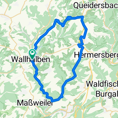
Pfalz M06 (Kessel)
Eine Fahrradroute, die in Wallhalben, Rheinland-Pfalz, Bundesrepublik Deutschland beginnt.
Übersicht
Über diese Route
<span style="font-family: Univers; color: black; font-size: 10pt; font-weight: normal; language: de; mso-ascii-font-family: Univers; mso-fareast-font-family: +mn-ea; mso-bidi-font-family: +mn-cs; mso-color-index: 1; mso-font-kerning: 12.0pt;">Die Tour beginnt in Wallhalben am Hotel Landgrafenmühle. Es ist eine kurze Rundtour die uns Orte um Wallhalben etwas näherbringt. Um auch den Ansprüchen der Mountainbiker gerecht zu werden, sind einige kurze </span><span style="font-family: Univers; color: black; font-size: 10pt; font-weight: normal; language: de; mso-ascii-font-family: Univers; mso-fareast-font-family: +mn-ea; mso-bidi-font-family: +mn-cs; mso-color-index: 1; mso-font-kerning: 12.0pt;">Trailpassagen</span><span style="font-family: Univers; color: black; font-size: 10pt; font-weight: normal; language: de; mso-ascii-font-family: Univers; mso-fareast-font-family: +mn-ea; mso-bidi-font-family: +mn-cs; mso-color-index: 1; mso-font-kerning: 12.0pt;"> in die Tour eingebunden. Aus diesem Grund wird auch </span><span style="font-family: Univers; color: black; font-size: 10pt; font-weight: normal; language: de; mso-ascii-font-family: Univers; mso-fareast-font-family: +mn-ea; mso-bidi-font-family: +mn-cs; mso-color-index: 1; mso-font-kerning: 12.0pt;">Herschberg</span><span style="font-family: Univers; color: black; font-size: 10pt; font-weight: normal; language: de; mso-ascii-font-family: Univers; mso-fareast-font-family: +mn-ea; mso-bidi-font-family: +mn-cs; mso-color-index: 1; mso-font-kerning: 12.0pt;"> zweimal </span><span style="font-family: Univers; color: black; font-size: 10pt; font-weight: normal; language: de; mso-ascii-font-family: Univers; mso-fareast-font-family: +mn-ea; mso-bidi-font-family: +mn-cs; mso-color-index: 1; mso-font-kerning: 12.0pt;">duchfahren</span><span style="font-family: Univers; color: black; font-size: 10pt; font-weight: normal; language: de; mso-ascii-font-family: Univers; mso-fareast-font-family: +mn-ea; mso-bidi-font-family: +mn-cs; mso-color-index: 1; mso-font-kerning: 12.0pt;">. Wer diese Tour noch etwas erweitern möchte wird im Wallhalbetal oder rund um den Kessel noch einige interessante </span><span style="font-family: Univers; color: black; font-size: 10pt; font-weight: normal; language: de; mso-ascii-font-family: Univers; mso-fareast-font-family: +mn-ea; mso-bidi-font-family: +mn-cs; mso-color-index: 1; mso-font-kerning: 12.0pt;">Trails</span><span style="font-family: Univers; color: black; font-size: 10pt; font-weight: normal; language: de; mso-ascii-font-family: Univers; mso-fareast-font-family: +mn-ea; mso-bidi-font-family: +mn-cs; mso-color-index: 1; mso-font-kerning: 12.0pt;"> finden.</span>
- -:--
- Dauer
- 19,6 km
- Distanz
- 410 m
- Aufstieg
- 410 m
- Abstieg
- ---
- Ø-Tempo
- ---
- Max. Höhe
Routenqualität
Wegtypen und Untergründe entlang der Route
Wegtypen
Forst- / Feldweg
10,8 km
(55 %)
Pfad
2,7 km
(14 %)
Untergründe
Befestigt
8,8 km
(45 %)
Unbefestigt
5,1 km
(26 %)
Asphalt
7,3 km
(37 %)
Schotter
2,6 km
(13 %)
Weiter mit Bikemap
Diese Radroute verwenden, bearbeiten oder herunterladen
Du möchtest Pfalz M06 (Kessel) fahren oder sie für deine eigene Reise anpassen? Folgendes kannst du mit dieser Bikemap-Route machen:
Gratis Funktionen
- Speichere diese Route als Favorit oder in einer Sammlung
- Kopiere & plane deine eigene Version dieser Route
- Synchronisiere deine Route mit Garmin oder Wahoo
Premium-Funktionen
Kostenlose Testversion für 3 Tage oder einmalige Zahlung. Mehr über Bikemap Premium.
- Navigiere diese Route auf iOS & Android
- Exportiere eine GPX / KML-Datei dieser Route
- Erstelle deinen individuellen Ausdruck (Jetzt kostenlos ausprobieren)
- Lade diese Route für die Offline-Navigation herunter
Entdecke weitere Premium-Funktionen.
Bikemap Premium aktivierenVon unserer Community
Wallhalben: Andere beliebte Routen, die hier beginnen
 Pfalz M06 (Kessel)
- Distanz
- 19,6 km
- Aufstieg
- 410 m
- Abstieg
- 410 m
- Standort
- Wallhalben, Rheinland-Pfalz, Bundesrepublik Deutschland
 Wallhalben-Mühlenweg-Contwig-Winterbach
- Distanz
- 34,1 km
- Aufstieg
- 228 m
- Abstieg
- 227 m
- Standort
- Wallhalben, Rheinland-Pfalz, Bundesrepublik Deutschland
 Steinzeitmenschen und Wassermühlen in Wallhalben
- Distanz
- 14,6 km
- Aufstieg
- 332 m
- Abstieg
- 330 m
- Standort
- Wallhalben, Rheinland-Pfalz, Bundesrepublik Deutschland
 Wallhalben Tour
- Distanz
- 31,1 km
- Aufstieg
- 411 m
- Abstieg
- 346 m
- Standort
- Wallhalben, Rheinland-Pfalz, Bundesrepublik Deutschland
 Pfälzerwaldtour
- Distanz
- 69,6 km
- Aufstieg
- 722 m
- Abstieg
- 722 m
- Standort
- Wallhalben, Rheinland-Pfalz, Bundesrepublik Deutschland
 Pfalz M05 (Bärenhöhle)
- Distanz
- 70,5 km
- Aufstieg
- 510 m
- Abstieg
- 507 m
- Standort
- Wallhalben, Rheinland-Pfalz, Bundesrepublik Deutschland
 Landstuhl_Homburg Rundtour
- Distanz
- 70,7 km
- Aufstieg
- 399 m
- Abstieg
- 399 m
- Standort
- Wallhalben, Rheinland-Pfalz, Bundesrepublik Deutschland
 Pfalz M04 (Weihermühle)
- Distanz
- 19,3 km
- Aufstieg
- 386 m
- Abstieg
- 385 m
- Standort
- Wallhalben, Rheinland-Pfalz, Bundesrepublik Deutschland
In der App öffnen


