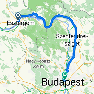
Kamenica-Pavlova-Salka-Chlaba 47km (area of Sturovo, Esztergom)

Eine Fahrradroute, die in Štúrovo, Nitriansky kraj, Slovak Republic beginnt.

Übersicht

Über diese Route

5

The Swim Route - MTB trip around Kamenica nad Hronom village in Sturovo / Esztergom areas nearby. I marked out few POIs of places to swim,  of nice views, etc. The MTB route is touching villages as well (grocery stores, pubs). Tried to create a scenic route to show the true character of this area combined with MTB technical passages as well. Without cars at all, except last few kilometers. Definitely recommend a MTB 29er, ideally full suspension. The route is not for children. If you are looking for tough-ish, multisurfaced route packed with short rock garden, sand, field, grass, rivers (Danube, Hron, Ipel), forests to reward yourself at the end, this is your route. In july, august the temperature can reach 33-35 °C.

-:--
Dauer
46,7 km
Distanz
254 m
Aufstieg
252 m
Abstieg
---
Ø-Tempo
---
Ø-Tempo
Alphastroke
Alphastroke

Erstellt vor 4 Jahren

Fotos von der Route

Foto 1 der Bikemap-Route "Kamenica-Pavlova-Salka-Chlaba 47km (area of Sturovo, Esztergom)"Foto 2 der Bikemap-Route "Kamenica-Pavlova-Salka-Chlaba 47km (area of Sturovo, Esztergom)"Foto 3 der Bikemap-Route "Kamenica-Pavlova-Salka-Chlaba 47km (area of Sturovo, Esztergom)"Foto 4 der Bikemap-Route "Kamenica-Pavlova-Salka-Chlaba 47km (area of Sturovo, Esztergom)"Foto 5 der Bikemap-Route "Kamenica-Pavlova-Salka-Chlaba 47km (area of Sturovo, Esztergom)"Foto 6 der Bikemap-Route "Kamenica-Pavlova-Salka-Chlaba 47km (area of Sturovo, Esztergom)"Foto 7 der Bikemap-Route "Kamenica-Pavlova-Salka-Chlaba 47km (area of Sturovo, Esztergom)"Foto 8 der Bikemap-Route "Kamenica-Pavlova-Salka-Chlaba 47km (area of Sturovo, Esztergom)"

Routenqualität

Wegtypen und Untergründe entlang der Route

Highlights der Route

POIs entlang der Route

  1. Hebe Bild 1 entlang der Bikemap-Route "Kamenica-Pavlova-Salka-Chlaba 47km (area of Sturovo, Esztergom)" hervor

    Interessanter Ort nach 1,4 km

    Pebble beach under the bridge. However the water level can be higher. As for now, in september. Summer months are ideal.

  2. Hebe Bild 2 entlang der Bikemap-Route "Kamenica-Pavlova-Salka-Chlaba 47km (area of Sturovo, Esztergom)" hervor

    Interessanter Ort nach 9,6 km

    You can refresh yourself here, small pebble beach. The level of water can be higher.

  3. Hebe Bild 3 entlang der Bikemap-Route "Kamenica-Pavlova-Salka-Chlaba 47km (area of Sturovo, Esztergom)" hervor

    Interessanter Ort nach 11,8 km

    You can swim here, pebble beach under the bridge. However water level is higher this time.

  4. Hebe Bild 4 entlang der Bikemap-Route "Kamenica-Pavlova-Salka-Chlaba 47km (area of Sturovo, Esztergom)" hervor

    Interessanter Ort nach 12,6 km

    WWII monument. I think it was built in 1986. Tank T-34. Museum of WWII not so far in Pohronsky Ruskov village.

  5. Hebe Bild 5 entlang der Bikemap-Route "Kamenica-Pavlova-Salka-Chlaba 47km (area of Sturovo, Esztergom)" hervor

    Interessanter Ort nach 13,9 km

    Go over the bridge. Perec creek.

  6. Hebe Bild 6 entlang der Bikemap-Route "Kamenica-Pavlova-Salka-Chlaba 47km (area of Sturovo, Esztergom)" hervor

    Interessanter Ort nach 16,4 km

    Nice vantage point, you can see hills around, Nitra city area in the far background, cooling towers of nuclear power plant in Mochovce are not so far.

  7. Hebe Bild 7 entlang der Bikemap-Route "Kamenica-Pavlova-Salka-Chlaba 47km (area of Sturovo, Esztergom)" hervor

    Interessanter Ort nach 17,3 km

    Loooooooong climb. South part of SK is flat-ish. Not here. A nice workout.

  8. Hebe Bild 8 entlang der Bikemap-Route "Kamenica-Pavlova-Salka-Chlaba 47km (area of Sturovo, Esztergom)" hervor

    Interessanter Ort nach 19,5 km

    En route to Salka village with the hills of "Duna Ipoly nemzeti park" nature reserve in the background. The "Csovanyos" has 913m and is located cca. 15km far away.

  9. Hebe Bild 9 entlang der Bikemap-Route "Kamenica-Pavlova-Salka-Chlaba 47km (area of Sturovo, Esztergom)" hervor

    Interessanter Ort nach 21 km

    Water well.

  10. Hebe Bild 10 entlang der Bikemap-Route "Kamenica-Pavlova-Salka-Chlaba 47km (area of Sturovo, Esztergom)" hervor

    Interessanter Ort nach 21,1 km

    Shelter, water well nearby.

  11. Hebe Bild 11 entlang der Bikemap-Route "Kamenica-Pavlova-Salka-Chlaba 47km (area of Sturovo, Esztergom)" hervor

    Interessanter Ort nach 24,8 km

    Leaving Salka village. Heading towards Lela.

  12. Hebe Bild 12 entlang der Bikemap-Route "Kamenica-Pavlova-Salka-Chlaba 47km (area of Sturovo, Esztergom)" hervor

    Interessanter Ort nach 27,3 km

    Leaving Lela village behind.

  13. Hebe Bild 13 entlang der Bikemap-Route "Kamenica-Pavlova-Salka-Chlaba 47km (area of Sturovo, Esztergom)" hervor

    Interessanter Ort nach 28,8 km

    Rock garden passage. A technical stuff.

  14. Hebe Bild 14 entlang der Bikemap-Route "Kamenica-Pavlova-Salka-Chlaba 47km (area of Sturovo, Esztergom)" hervor

    Interessanter Ort nach 33,9 km

    Sand hole in the ground.

  15. Hebe Bild 15 entlang der Bikemap-Route "Kamenica-Pavlova-Salka-Chlaba 47km (area of Sturovo, Esztergom)" hervor

    Interessanter Ort nach 35,6 km

    Meeting of "Ipel" (SK) / "Ipoly" (HU) and Danube rivers, you can swim here, muddy kinda access to the river, better for fishing and enjoying the view.

  16. Hebe Bild 16 entlang der Bikemap-Route "Kamenica-Pavlova-Salka-Chlaba 47km (area of Sturovo, Esztergom)" hervor

    Interessanter Ort nach 36,1 km

    Pebble beaches, access is tricky, you have to find steps dig out in the ground, ideal place for swimming, sunbathing. The Danube river is colder than Ipel or Hron.

  17. Hebe Bild 17 entlang der Bikemap-Route "Kamenica-Pavlova-Salka-Chlaba 47km (area of Sturovo, Esztergom)" hervor

    Interessanter Ort nach 36,5 km

    Danubian sunset with a sandy beach.

Weiter mit Bikemap

Diese Radroute verwenden, bearbeiten oder herunterladen

Du möchtest Kamenica-Pavlova-Salka-Chlaba 47km (area of Sturovo, Esztergom) fahren oder sie für deine eigene Reise anpassen? Folgendes kannst du mit dieser Bikemap-Route machen:

Gratis Funktionen

Premium-Funktionen

Kostenlose Testversion für 3 Tage oder einmalige Zahlung. Mehr über Bikemap Premium.

  • Navigiere diese Route auf iOS & Android
  • Exportiere eine GPX / KML-Datei dieser Route
  • Erstelle deinen individuellen Ausdruck (Jetzt kostenlos ausprobieren)
  • Lade diese Route für die Offline-Navigation herunter

Entdecke weitere Premium-Funktionen.

Bikemap Premium aktivieren

Von unserer Community

Štúrovo: Andere beliebte Routen, die hier beginnen