Easy ride in Chaska
- 16,1 km
- 138 m
- 138 m
- Chaska, Minnesota, Vereinigte Staaten
Eine Fahrradroute, die in Chaska, Minnesota, Vereinigte Staaten beginnt.
Übersicht
Die Rückfahrt kann über Hennepin erfolgen (hat Fahrradwege in beide Richtungen). Die Fahrspuren enden an der Washington Av, sodass man in den Verkehr einfädeln muss. Man kann Hennepin zur 11th St nehmen, um zurück zum Cedar Lake Trail zu gelangen.
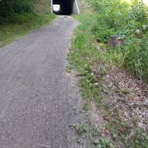
Der SW LRT Trail ist ein verdichteter Schotterweg, auf dem man mit schmalen Reifen fahren kann, da der Kies normalerweise nicht tief ist. Der Weg beginnt an der Flying Cloud Blvd, und der Eingang ist nicht sehr offensichtlich.
Erstellt vor 17 Jahren
Highlights der Route
Gravel LRT trail starts
Cross street to start of Greenway
Exit to Kennilworth/Cedar Lake Trail
Cedar Lake Trail Connection
Cedar Lake Trail exit to Glenwood
Weiter mit Bikemap
Du möchtest B2B00838 55318>55414 via SWLRT, Greenway, Cedar Lake Trl fahren oder sie für deine eigene Reise anpassen? Folgendes kannst du mit dieser Bikemap-Route machen:
Kostenlose Testversion für 3 Tage oder einmalige Zahlung. Mehr über Bikemap Premium.
Entdecke weitere Premium-Funktionen.
Bikemap Premium aktivierenVon unserer Community
In der App öffnen