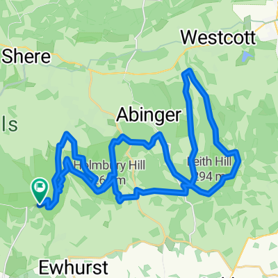
Cranleigh loop south
- 37,9 km
- 175 m
- 176 m
- Cranleigh, England, Vereinigtes Königreich
Eine Fahrradroute, die in Cranleigh, England, Vereinigtes Königreich beginnt.
Übersicht
Dies ist definitiv eine nur für Mountainbikes gedachte Route, die Pitch Hill, Holmbury Hill (zweimal) und Leith Hill umfasst.
Gehe sehr kurz nach Süden aus Peaslake entlang des Walking Bottom und biege auf Pitch Hill ab. Nach der Auffahrt auf Pitch Hill überquere die Ewhurst Road und fahre (wahrscheinlich die Fahrräder schiebend) den Holmbury Hill hinauf in Richtung des Stausees. Halte dich nach Südosten, bis du den Gipfel des Holmbury Hill erreichst. Nimm die Yogurt Pots (ich glaube, sie haben den Eingang seit meiner letzten Tour geändert) und dann die Telegraph Road hinunter nach Holmbury Saint Mary. In Holmbury Saint Mary halte dich an den Straßen, bis du den Reitweg von der Pasture Wood Road erreichst. Gehe den Reitweg hinauf, bis du die Straße erreichst, auf die du links abbiegst und die zum zweiten Parkplatz auf deiner linken Seite hinunterführst. Jetzt geht es richtig bergauf auf Leith Hill, folge dem Radweg hinauf zum Leith Hill Tower und dann auf der anderen Seite hinunter (sei vorsichtig, die Abfahrt gleich nach dem Leith Hill Tower kann etwas schwierig sein). Folge dem Pfad hinunter bis zum Cricketplatz und biege dann links neben dem Zaun nach dem Cricketplatz ab, der dich zu den Bombenlöchern, Deliverance (wenn du verrückt bist) und schließlich zum Eingang des Regurgitator führt. Am Ende des Regurgitator biegst du links den Hügel hinauf zur Summer Lightning ab und folgst diesem Weg bis zum Lookout Tower. Nach dem Lookout Tower gehe hinunter zur Whiteberry Road, die Teil des Greensand Way ist, und nutze die Straßen und Trails bis Friday Street. Auf halbem Weg den Hügel von Friday Street hinauf, biegt der Reitweg links in eine steile Kerbe ab und nach einer kurzen Strecke auf der Straße kannst du die Abfahrt auf dem Reitweg von der Pasture Wood Road in Angriff nehmen. Dann geht es zurück nach Holmbury Hill zum Stausee und dann hinunter Resevoir Dogs/Barry Knows Best, was dich fast zurück nach Peaslake bringt.
Es ist ein ziemlich technischer und sehr hügeliger Tag. Ich würde vier bis fünf Stunden einplanen, es sei denn, du bist sehr fit und sehr schnell und frühstückst technische Sachen. Für uns gewöhnliche Sterbliche ist es ein langer harter Tag, aber sehr lohnend.
Erstellt vor 17 Jahren
Highlights der Route
The entrance to Summer Lightning MTB trail.
Lookout Tower at the end of Summer Lightning MTB trail.
Weiter mit Bikemap
Du möchtest North Downs Nobbler fahren oder sie für deine eigene Reise anpassen? Folgendes kannst du mit dieser Bikemap-Route machen:
Kostenlose Testversion für 3 Tage oder einmalige Zahlung. Mehr über Bikemap Premium.
Entdecke weitere Premium-Funktionen.
Bikemap Premium aktivierenVon unserer Community
In der App öffnen