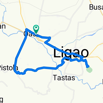
Tobgon River Loop avoiding National Hi-ways and Dense Roads
Eine Fahrradroute, die in Iraya, Bicol, Philippines beginnt.
Übersicht
Über diese Route
From Binatagan to Greenfield Road to Irrigation Road parallel to Tobgon River upstrem. Turned right to avoid Sabido Road and looped back via Sabloyon Road. Then made a right turn again at Batang to again avoid the national hi-way going back to Ligao Centro. And finally back to starting point.
- -:--
- Dauer
- 15,7 km
- Distanz
- 56 m
- Aufstieg
- 55 m
- Abstieg
- ---
- Ø-Tempo
- 98 m
- Ø-Tempo
Weiter mit Bikemap
Diese Radroute verwenden, bearbeiten oder herunterladen
Du möchtest Tobgon River Loop avoiding National Hi-ways and Dense Roads fahren oder sie für deine eigene Reise anpassen? Folgendes kannst du mit dieser Bikemap-Route machen:
Gratis Funktionen
- Speichere diese Route als Favorit oder in einer Sammlung
- Kopiere & plane deine eigene Version dieser Route
- Synchronisiere deine Route mit Garmin oder Wahoo
Premium-Funktionen
Kostenlose Testversion für 3 Tage oder einmalige Zahlung. Mehr über Bikemap Premium.
- Navigiere diese Route auf iOS & Android
- Exportiere eine GPX / KML-Datei dieser Route
- Erstelle deinen individuellen Ausdruck (Jetzt kostenlos ausprobieren)
- Lade diese Route für die Offline-Navigation herunter
Entdecke weitere Premium-Funktionen.
Bikemap Premium aktivierenVon unserer Community
Iraya: Andere beliebte Routen, die hier beginnen
- Municipal Road, Oas to Municipal Road, Oas
- Distanz
- 18,2 km
- Aufstieg
- 0 m
- Abstieg
- 7 m
- Standort
- Iraya, Bicol, Philippinen
- Oas-Ponso Loop Clockwise
- Distanz
- 20,3 km
- Aufstieg
- 43 m
- Abstieg
- 41 m
- Standort
- Iraya, Bicol, Philippinen
- Maporong, Oas to Maporong, Oas
- Distanz
- 12,3 km
- Aufstieg
- 391 m
- Abstieg
- 391 m
- Standort
- Iraya, Bicol, Philippinen
- Basud - Dike River Trail
- Distanz
- 4,4 km
- Aufstieg
- 9 m
- Abstieg
- 9 m
- Standort
- Iraya, Bicol, Philippinen
- Tobgon River Loop avoiding National Hi-ways and Dense Roads
- Distanz
- 15,7 km
- Aufstieg
- 56 m
- Abstieg
- 55 m
- Standort
- Iraya, Bicol, Philippinen
- Municipal Road, Oas to Municipal Road, Oas
- Distanz
- 14,7 km
- Aufstieg
- 9 m
- Abstieg
- 49 m
- Standort
- Iraya, Bicol, Philippinen
- Rumualdo Street, Oas to Amtic
- Distanz
- 19,4 km
- Aufstieg
- 482 m
- Abstieg
- 55 m
- Standort
- Iraya, Bicol, Philippinen
- Municipal Road, Oas to Municipal Road, Oas
- Distanz
- 39 km
- Aufstieg
- 254 m
- Abstieg
- 255 m
- Standort
- Iraya, Bicol, Philippinen
In der App öffnen