- 25,9 km
- 85 m
- 87 m
- Chiang Mai, Chiang Mai, Thailand
Samoeng Loop
Eine Fahrradroute, die in Chiang Mai, Chiang Mai, Thailand beginnt.
Übersicht
Über diese Route
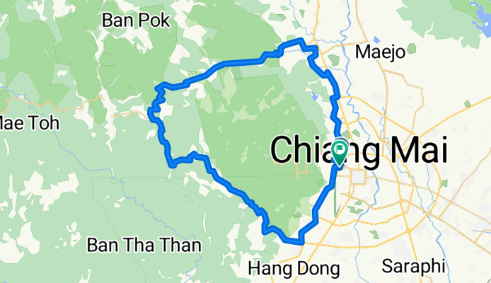
Classic Ride around the mountains of Chiang Mai:
From Chiang Mai take Canal Road South to Samoeng Intersection. Then enter the valley in Eastern direction eventually starting to climb. After km 35 and reaching an altitude of approx 800 m, several steep switchbacks will take you down to about 550 m above sea level. The next climb is 5 kms and 400 m climb.
After the next downhill of about 2 km, take a right turn direction Mae Rim and do the third and final climb.
You will be rewarded with a nice and extended downhill.
At km 69 turn right, and at km 71 - after crossing a bridge - again right. Then follow the road along the river until you reach highway 107. U-turn there and follow direction Chiang Mai then at km 78 turn right at the traffic lights to follow Canal Road back to Chiang Mai.
- -:--
- Dauer
- 87,7 km
- Distanz
- 1.132 m
- Aufstieg
- 1.130 m
- Abstieg
- ---
- Ø-Tempo
- ---
- Max. Höhe
Erstellt vor 15 Jahren
Weiter mit Bikemap
Diese Radroute verwenden, bearbeiten oder herunterladen
Du möchtest Samoeng Loop fahren oder sie für deine eigene Reise anpassen? Folgendes kannst du mit dieser Bikemap-Route machen:
Gratis Funktionen
- Speichere diese Route als Favorit oder in einer Sammlung
- Kopiere & plane deine eigene Version dieser Route
- Teile sie in Etappen ein, um eine mehrtägige Tour zu erstellen
- Synchronisiere deine Route mit Garmin oder Wahoo
Premium-Funktionen
Kostenlose Testversion für 3 Tage oder einmalige Zahlung. Mehr über Bikemap Premium.
- Navigiere diese Route auf iOS & Android
- Exportiere eine GPX / KML-Datei dieser Route
- Erstelle deinen individuellen Ausdruck (Jetzt kostenlos ausprobieren)
- Lade diese Route für die Offline-Navigation herunter
Entdecke weitere Premium-Funktionen.
Bikemap Premium aktivierenVon unserer Community
Chiang Mai: Andere beliebte Routen, die hier beginnen
- 18.805, 98.960 to 18.803, 98.960
- circle round the airport
- 22,4 km
- 78 m
- 80 m
- Chiang Mai, Chiang Mai, Thailand
- Sitthiwong Road, Mueang Chiang Mai District to Sitthiwong Road, Mueang Chiang Mai District
- 28,7 km
- 139 m
- 140 m
- Chiang Mai, Chiang Mai, Thailand
- Chiang Mai Provincial Livestock Office to Mu Ban Seagames Village Orange Road
- 72,3 km
- 3.879 m
- 3.854 m
- Chiang Mai, Chiang Mai, Thailand
- เจ็ดยà¸à¸”-ห้วยตึงเฒ่า-ลานเนินนุ่ม
- 25,3 km
- 214 m
- 227 m
- Chiang Mai, Chiang Mai, Thailand
- Chiang Mai - Mae Taeng
- 43,6 km
- 171 m
- 120 m
- Chiang Mai, Chiang Mai, Thailand
- Chiang Mai - Mae Tha
- 64,7 km
- 313 m
- 235 m
- Chiang Mai, Chiang Mai, Thailand
- War San Pu Loei
- 36,4 km
- 84 m
- 90 m
- Chiang Mai, Chiang Mai, Thailand
In der App öffnen


