
Panonska nižina - Osijek
A collection of 7 cycling routes, created by Grega Flajnik.
Overview
About this collection
This route collection contains 7 cycling routes with a total length of 637.4 km.
- 7
- Routes
- 19 h 55 min
- Duration
- 637.4 km
- Distance
- 32 km/h
- Avg. speed
- 1,127 m
- Ascent
- 1,089 m
- Descent

Panonska nižina - Osijek
Routes in this collection
All 7 routes in this collection can be opened on the map or in the Bikemap App for more details, where you can adjust them in the route planner, or download them as GPX or KML file. Use them as a template for planning your own rides, or let Bikemap navigate you along them directly.

Panonska nižina Osijek skupna
Cycling route in Osijek, County of Osijek-Baranja, Croatia
- 266.9 km
- Distance
- 417 m
- Ascent
- 416 m
- Descent
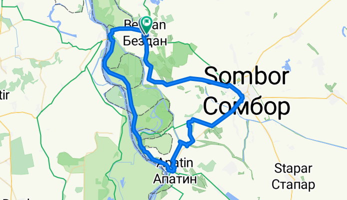
Panonska 3. dan_Vojvodina
Cycling route in Sombor, Vojvodina, Serbia
- 76.3 km
- Distance
- 73 m
- Ascent
- 74 m
- Descent

Panonska 2. dan Karanac - Bezdan Kopački Rit
Cycling route in Sombor, Vojvodina, Serbia
- 78.5 km
- Distance
- 118 m
- Ascent
- 94 m
- Descent

Panonska 4. dan Bezdan - Karanac
Cycling route in Sombor, Vojvodina, Serbia
- 41.1 km
- Distance
- 312 m
- Ascent
- 286 m
- Descent

Ramarin - Slavonski Brod
Cycling route in Garčin, Brod-Posavina County, Croatia
- 42.8 km
- Distance
- 73 m
- Ascent
- 72 m
- Descent


Panonska 1. dan - Slavonski brod krog
Cycling route in Brod, Republika Srpska, Bosnia and Herzegovina
- 32.2 km
- Distance
- 95 m
- Ascent
- 105 m
- Descent