

EM-Lahr
A cycling route starting in Emmendingen, Baden-Wurttemberg, Germany.
Overview
About this route
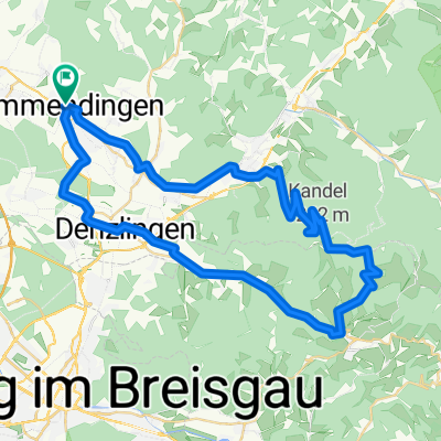
The route through Freiamt and the Schutter valley to Lahr is a beautiful ride because the view over Freiamt is great and the bike almost rides itself through the Schutter valley. On the way back via the Rhine plain, it's an easy and manageable route. The only downside is the traffic in Lahr.
- -:--
- Duration
- 99.4 km
- Distance
- 412 m
- Ascent
- 412 m
- Descent
- ---
- Avg. speed
- ---
- Max. altitude
Route quality
Waytypes & surfaces along the route
Waytypes
Track
19.9 km
(20 %)
Road
17.9 km
(18 %)
Surfaces
Paved
85.5 km
(86 %)
Asphalt
77.6 km
(78 %)
Paved (undefined)
8 km
(8 %)
Undefined
13.9 km
(14 %)
Continue with Bikemap
Use, edit, or download this cycling route
You would like to ride EM-Lahr or customize it for your own trip? Here is what you can do with this Bikemap route:
Free features
- Save this route as favorite or in collections
- Copy & plan your own version of this route
- Split it into stages to create a multi-day tour
- Sync your route with Garmin or Wahoo
Premium features
Free trial for 3 days, or one-time payment. More about Bikemap Premium.
- Navigate this route on iOS & Android
- Export a GPX / KML file of this route
- Create your custom printout (try it for free)
- Download this route for offline navigation
Discover more Premium features.
Get Bikemap PremiumFrom our community
Other popular routes starting in Emmendingen
 Lessingstraße 7A nach Ensisheimer Straße
- Distance
- 15.7 km
- Ascent
- 69 m
- Descent
- 30 m
- Location
- Emmendingen, Baden-Wurttemberg, Germany
 EM rund um Freiamt
- Distance
- 39.6 km
- Ascent
- 728 m
- Descent
- 728 m
- Location
- Emmendingen, Baden-Wurttemberg, Germany
 Landkreis EM (EM-Kaiserstuhl-March-Freiamt-EM)
- Distance
- 74.4 km
- Ascent
- 647 m
- Descent
- 564 m
- Location
- Emmendingen, Baden-Wurttemberg, Germany
 EM - Kandel -EM
- Distance
- 54.4 km
- Ascent
- 994 m
- Descent
- 994 m
- Location
- Emmendingen, Baden-Wurttemberg, Germany
 Lessingstraße 7A nach Ensisheimer Straße beste Route
- Distance
- 15.9 km
- Ascent
- 72 m
- Descent
- 33 m
- Location
- Emmendingen, Baden-Wurttemberg, Germany
 Emmendingen-Freiamt
- Distance
- 43.4 km
- Ascent
- 337 m
- Descent
- 337 m
- Location
- Emmendingen, Baden-Wurttemberg, Germany
 Schillingerbergrunde
- Distance
- 35 km
- Ascent
- 841 m
- Descent
- 781 m
- Location
- Emmendingen, Baden-Wurttemberg, Germany
 Test Emmendingen
- Distance
- 2.7 km
- Ascent
- 0 m
- Descent
- 8 m
- Location
- Emmendingen, Baden-Wurttemberg, Germany
Open it in the app