![U Rathaus Reinickendorf (Bln)[Bus Am Nordgraben], Berlin to Holzhauser Straße 85, Berlin](/_next/static/media/contour-lines-light-small.cafd5e5d.avif)
![U Rathaus Reinickendorf (Bln)[Bus Am Nordgraben], Berlin to Holzhauser Straße 85, Berlin](https://media.bikemap.net/routes/12428527/staticmaps/in_eda685e7-21c5-4184-a6b6-a3032195262a_694x400_bikemap-2021-3D-static.png)
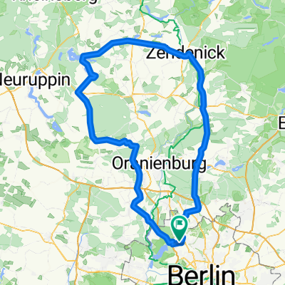
U Rathaus Reinickendorf (Bln)[Bus Am Nordgraben], Berlin to Holzhauser Straße 85, Berlin
A cycling route starting in Wittenau, Land Berlin, Germany.
Overview
About this route
- 6 min
- Duration
- 1.7 km
- Distance
- 7 m
- Ascent
- 9 m
- Descent
- 17.7 km/h
- Avg. speed
- 50 m
- Avg. speed

Route quality
Waytypes & surfaces along the route
Waytypes
Cycleway
0.7 km
(43 %)
Pedestrian area
0.6 km
(34 %)
Surfaces
Paved
1.5 km
(93 %)
Asphalt
0.8 km
(48 %)
Paving stones
0.7 km
(44 %)
Undefined
0.1 km
(7 %)
Continue with Bikemap
Use, edit, or download this cycling route
You would like to ride U Rathaus Reinickendorf (Bln)[Bus Am Nordgraben], Berlin to Holzhauser Straße 85, Berlin or customize it for your own trip? Here is what you can do with this Bikemap route:
Free features
- Save this route as favorite or in collections
- Copy & plan your own version of this route
- Sync your route with Garmin or Wahoo
Premium features
Free trial for 3 days, or one-time payment. More about Bikemap Premium.
- Navigate this route on iOS & Android
- Export a GPX / KML file of this route
- Create your custom printout (try it for free)
- Download this route for offline navigation
Discover more Premium features.
Get Bikemap PremiumFrom our community
Other popular routes starting in Wittenau
 Nordgraben-Panke bearb.
- Distance
- 29.5 km
- Ascent
- 58 m
- Descent
- 60 m
- Location
- Wittenau, Land Berlin, Germany
 FÖV Tour 2017 – Botanischer Volkspark Blankenfelde-Pankow
- Distance
- 20.1 km
- Ascent
- 82 m
- Descent
- 82 m
- Location
- Wittenau, Land Berlin, Germany
 FÖV Tour 2016 – Bürgerpark Pankow
- Distance
- 17.5 km
- Ascent
- 18 m
- Descent
- 18 m
- Location
- Wittenau, Land Berlin, Germany
 FÖV Tour 2018 – Strandbad Lübars "Kontraste der Großstadt"
- Distance
- 21.4 km
- Ascent
- 96 m
- Descent
- 91 m
- Location
- Wittenau, Land Berlin, Germany
 beste Rennradstrecke!!!!
- Distance
- 142.4 km
- Ascent
- 149 m
- Descent
- 149 m
- Location
- Wittenau, Land Berlin, Germany
 32 km Trainingstour
- Distance
- 32.8 km
- Ascent
- 76 m
- Descent
- 78 m
- Location
- Wittenau, Land Berlin, Germany
 Wittenau-Waldspielplatz-Ludolfinger-Wittenau
- Distance
- 19.8 km
- Ascent
- 78 m
- Descent
- 75 m
- Location
- Wittenau, Land Berlin, Germany
 43 km Rundtour Henningsdorf, Schönwalde
- Distance
- 41.3 km
- Ascent
- 101 m
- Descent
- 101 m
- Location
- Wittenau, Land Berlin, Germany
Open it in the app