
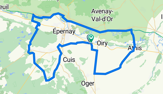
Epernay_70
A cycling route starting in Mareuil-sur-Ay, Grand Est, France.
Overview
About this route
- -:--
- Duration
- 71.3 km
- Distance
- 525 m
- Ascent
- 517 m
- Descent
- ---
- Avg. speed
- 254 m
- Max. altitude

Route quality
Waytypes & surfaces along the route
Waytypes
Road
32.8 km
(46 %)
Path
10 km
(14 %)
Surfaces
Paved
44.2 km
(62 %)
Unpaved
2.1 km
(3 %)
Asphalt
44.2 km
(62 %)
Unpaved (undefined)
0.7 km
(1 %)
Continue with Bikemap
Use, edit, or download this cycling route
You would like to ride Epernay_70 or customize it for your own trip? Here is what you can do with this Bikemap route:
Free features
- Save this route as favorite or in collections
- Copy & plan your own version of this route
- Sync your route with Garmin or Wahoo
Premium features
Free trial for 3 days, or one-time payment. More about Bikemap Premium.
- Navigate this route on iOS & Android
- Export a GPX / KML file of this route
- Create your custom printout (try it for free)
- Download this route for offline navigation
Discover more Premium features.
Get Bikemap PremiumFrom our community
Other popular routes starting in Mareuil-sur-Ay
 Stage 06 Tour de France 2012 - Épernay to Metz
- Distance
- 203.8 km
- Ascent
- 794 m
- Descent
- 683 m
- Location
- Mareuil-sur-Ay, Grand Est, France
 Epernay_70
- Distance
- 71.3 km
- Ascent
- 525 m
- Descent
- 517 m
- Location
- Mareuil-sur-Ay, Grand Est, France
 Mareuil-sur-Aÿ - Hautvillers
- Distance
- 24.2 km
- Ascent
- 256 m
- Descent
- 256 m
- Location
- Mareuil-sur-Ay, Grand Est, France
 La Cote des Blancs nord - Circuit cyclotouristique
- Distance
- 21.4 km
- Ascent
- 311 m
- Descent
- 311 m
- Location
- Mareuil-sur-Ay, Grand Est, France
 La Cote des Blancs nord - Circuit cyclotouristique
- Distance
- 21.3 km
- Ascent
- 362 m
- Descent
- 360 m
- Location
- Mareuil-sur-Ay, Grand Est, France
 Epernay1
- Distance
- 45.2 km
- Ascent
- 529 m
- Descent
- 530 m
- Location
- Mareuil-sur-Ay, Grand Est, France
 Epernay66
- Distance
- 66.1 km
- Ascent
- 680 m
- Descent
- 680 m
- Location
- Mareuil-sur-Ay, Grand Est, France
 Chouilly
- Distance
- 54.1 km
- Ascent
- 280 m
- Descent
- 279 m
- Location
- Mareuil-sur-Ay, Grand Est, France
Open it in the app