
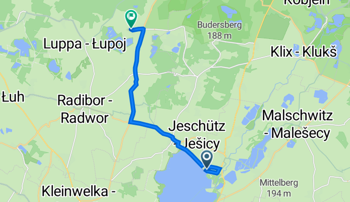
Gewerbepark Niedergurig 6, Malschwitz nach Lomske 4, Radibor
A cycling route starting in Großdubrau, Saxony, Germany.
Overview
About this route
- 23 min
- Duration
- 9.4 km
- Distance
- 29 m
- Ascent
- 41 m
- Descent
- 24.1 km/h
- Avg. speed
- 185 m
- Avg. speed

Route quality
Waytypes & surfaces along the route
Waytypes
Busy road
5.7 km
(60 %)
Access road
1.7 km
(18 %)
Surfaces
Paved
8 km
(86 %)
Asphalt
7.6 km
(81 %)
Concrete
0.5 km
(5 %)
Undefined
1.4 km
(14 %)
Continue with Bikemap
Use, edit, or download this cycling route
You would like to ride Gewerbepark Niedergurig 6, Malschwitz nach Lomske 4, Radibor or customize it for your own trip? Here is what you can do with this Bikemap route:
Free features
- Save this route as favorite or in collections
- Copy & plan your own version of this route
- Sync your route with Garmin or Wahoo
Premium features
Free trial for 3 days, or one-time payment. More about Bikemap Premium.
- Navigate this route on iOS & Android
- Export a GPX / KML file of this route
- Create your custom printout (try it for free)
- Download this route for offline navigation
Discover more Premium features.
Get Bikemap PremiumFrom our community
Other popular routes starting in Großdubrau
 Am Staudamm 4, Malschwitz nach Lomske 4, Radibor
- Distance
- 8.9 km
- Ascent
- 31 m
- Descent
- 89 m
- Location
- Großdubrau, Saxony, Germany
 Teichtour durch Oberlausitzer Heide- und Teichlandschaft
- Distance
- 53.2 km
- Ascent
- 151 m
- Descent
- 153 m
- Location
- Großdubrau, Saxony, Germany
 Motorradroute Crosta/Berlin
- Distance
- 241.4 km
- Ascent
- 146 m
- Descent
- 262 m
- Location
- Großdubrau, Saxony, Germany
 Milkler Weg 3, Großdubrau nach Semmelweisstraße 24b, Hoyerswerda
- Distance
- 39.5 km
- Ascent
- 501 m
- Descent
- 524 m
- Location
- Großdubrau, Saxony, Germany
 opa besuchen
- Distance
- 26.9 km
- Ascent
- 133 m
- Descent
- 134 m
- Location
- Großdubrau, Saxony, Germany
 Mühlentour am Löbauer Wasser
- Distance
- 67.2 km
- Ascent
- 237 m
- Descent
- 237 m
- Location
- Großdubrau, Saxony, Germany
 Pielitzhöhe
- Distance
- 54 km
- Ascent
- 324 m
- Descent
- 324 m
- Location
- Großdubrau, Saxony, Germany
 Teichtour durch Oberlausitzer Heide- und Teichlandschaft
- Distance
- 53.3 km
- Ascent
- 107 m
- Descent
- 109 m
- Location
- Großdubrau, Saxony, Germany
Open it in the app