
2024_05_BikeMap
A cycling route starting in Włodawa, Lublin Voivodeship, Poland.
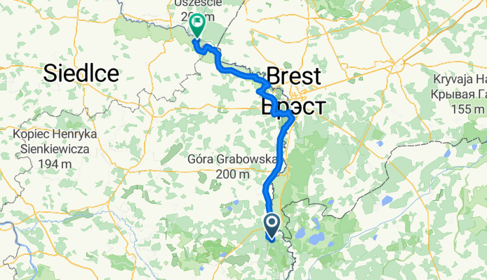
Overview
About this route
- 8 h 13 min
- Duration
- 144.3 km
- Distance
- 407 m
- Ascent
- 445 m
- Descent
- 17.6 km/h
- Avg. speed
- 175 m
- Max. altitude

Route quality
Waytypes & surfaces along the route
Waytypes
Road
53.4 km
(37 %)
Cycleway
28.9 km
(20 %)
Surfaces
Paved
124.1 km
(86 %)
Asphalt
124.1 km
(86 %)
Undefined
20.2 km
(14 %)
Continue with Bikemap
Use, edit, or download this cycling route
You would like to ride 2024_05_BikeMap or customize it for your own trip? Here is what you can do with this Bikemap route:
Free features
- Save this route as favorite or in collections
- Copy & plan your own version of this route
- Split it into stages to create a multi-day tour
- Sync your route with Garmin or Wahoo
Premium features
Free trial for 3 days, or one-time payment. More about Bikemap Premium.
- Navigate this route on iOS & Android
- Export a GPX / KML file of this route
- Create your custom printout (try it for free)
- Download this route for offline navigation
Discover more Premium features.
Get Bikemap PremiumFrom our community
Other popular routes starting in Włodawa
 NSR Włodawa - Hrubieszów
- Distance
- 144.7 km
- Ascent
- 253 m
- Descent
- 237 m
- Location
- Włodawa, Lublin Voivodeship, Poland
 wlodawa day2
- Distance
- 137.1 km
- Ascent
- 127 m
- Descent
- 120 m
- Location
- Włodawa, Lublin Voivodeship, Poland
 2024_05_BikeMap
- Distance
- 144.3 km
- Ascent
- 407 m
- Descent
- 445 m
- Location
- Włodawa, Lublin Voivodeship, Poland
 wlodawa terspol
- Distance
- 64.2 km
- Ascent
- 87 m
- Descent
- 127 m
- Location
- Włodawa, Lublin Voivodeship, Poland
 Trasa z Orchówek 179, Włodawa
- Distance
- 57.4 km
- Ascent
- 724 m
- Descent
- 734 m
- Location
- Włodawa, Lublin Voivodeship, Poland
 Polska 2014 Dzień 7
- Distance
- 42.9 km
- Ascent
- 107 m
- Descent
- 100 m
- Location
- Włodawa, Lublin Voivodeship, Poland
 Włodwa Cycle
- Distance
- 31.7 km
- Ascent
- 75 m
- Descent
- 79 m
- Location
- Włodawa, Lublin Voivodeship, Poland
 Suszno-czeremcha
- Distance
- 161.6 km
- Ascent
- 211 m
- Descent
- 191 m
- Location
- Włodawa, Lublin Voivodeship, Poland
Open it in the app