
Empire State Trail: North Tonawanda to South Lockport
A cycling route starting in North Tonawanda, New York, United States.
Overview
About this route
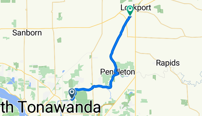
Roll the Erie Canal stretch from North Tonawanda to South Lockport on the Empire State Trail. It’s about 19 km of smooth, mostly paved cycleway with barely any climbing. Follow the canal, pass quiet neighborhoods, and finish by Lockport’s famous Flight of Five locks. Great for an easy spin or family ride. Watch for a few road crossings, bring water, and enjoy the canal views the whole way.
- -:--
- Duration
- 19.2 km
- Distance
- 44 m
- Ascent
- 43 m
- Descent
- ---
- Avg. speed
- 189 m
- Max. altitude
Route quality
Waytypes & surfaces along the route
Waytypes
Cycleway
17 km
(89 %)
Road
1.1 km
(6 %)
Quiet road
1 km
(5 %)
Surfaces
Paved
18.8 km
(98 %)
Asphalt
18.8 km
(98 %)
Undefined
0.4 km
(2 %)
Continue with Bikemap
Use, edit, or download this cycling route
You would like to ride Empire State Trail: North Tonawanda to South Lockport or customize it for your own trip? Here is what you can do with this Bikemap route:
Free features
- Save this route as favorite or in collections
- Copy & plan your own version of this route
- Sync your route with Garmin or Wahoo
Premium features
Free trial for 3 days, or one-time payment. More about Bikemap Premium.
- Navigate this route on iOS & Android
- Export a GPX / KML file of this route
- Create your custom printout (try it for free)
- Download this route for offline navigation
Discover more Premium features.
Get Bikemap PremiumFrom our community
Other popular routes starting in North Tonawanda
 Louisa Parkway 3, North Tonawanda to Sweeney Street 471, North Tonawanda
- Distance
- 17.3 km
- Ascent
- 33 m
- Descent
- 39 m
- Location
- North Tonawanda, New York, United States
 loop de loop
- Distance
- 6.1 km
- Ascent
- 0 m
- Descent
- 4 m
- Location
- North Tonawanda, New York, United States
 Our first bike ride of season!
- Distance
- 10.8 km
- Ascent
- 12 m
- Descent
- 12 m
- Location
- North Tonawanda, New York, United States
 Snail-like route in Amherst
- Distance
- 11.9 km
- Ascent
- 58 m
- Descent
- 50 m
- Location
- North Tonawanda, New York, United States
 windy day torcher
- Distance
- 7.2 km
- Ascent
- 22 m
- Descent
- 25 m
- Location
- North Tonawanda, New York, United States
 R4R 2020
- Distance
- 17.3 km
- Ascent
- 10 m
- Descent
- 18 m
- Location
- North Tonawanda, New York, United States
 Ellicott Creek Park Loop
- Distance
- 26.2 km
- Ascent
- 40 m
- Descent
- 37 m
- Location
- North Tonawanda, New York, United States
 Ellicott Creek Park to Lockport Road
- Distance
- 38.7 km
- Ascent
- 32 m
- Descent
- 33 m
- Location
- North Tonawanda, New York, United States
Open it in the app