
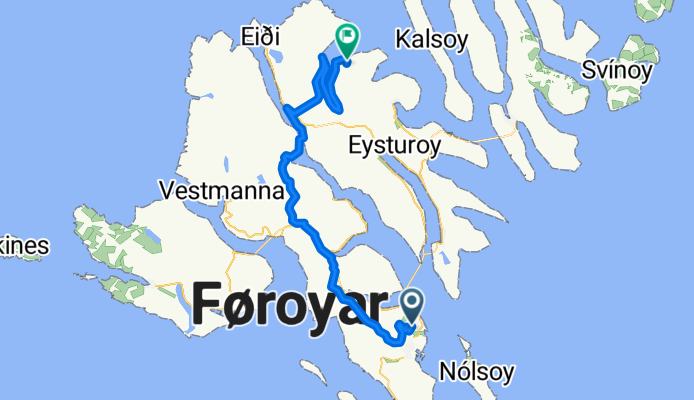
Djúpagilsvegur to Kirkjuvegur
A cycling route starting in Hoyvík, Streymoy region, Faroe Islands.
Overview
About this route
- 7 h 53 min
- Duration
- 64.1 km
- Distance
- 2,080 m
- Ascent
- 2,160 m
- Descent
- 8.1 km/h
- Avg. speed
- 497 m
- Max. altitude
Route quality
Waytypes & surfaces along the route
Waytypes
Path
17.3 km
(27 %)
Road
12.2 km
(19 %)
Surfaces
Paved
12.8 km
(20 %)
Unpaved
5.8 km
(9 %)
Asphalt
12.8 km
(20 %)
Gravel
3.2 km
(5 %)
Continue with Bikemap
Use, edit, or download this cycling route
You would like to ride Djúpagilsvegur to Kirkjuvegur or customize it for your own trip? Here is what you can do with this Bikemap route:
Free features
- Save this route as favorite or in collections
- Copy & plan your own version of this route
- Sync your route with Garmin or Wahoo
Premium features
Free trial for 3 days, or one-time payment. More about Bikemap Premium.
- Navigate this route on iOS & Android
- Export a GPX / KML file of this route
- Create your custom printout (try it for free)
- Download this route for offline navigation
Discover more Premium features.
Get Bikemap PremiumFrom our community
Other popular routes starting in Hoyvík
 Norðurlandahúsið, Tórshavn nach Sandoy
- Distance
- 22.8 km
- Ascent
- 514 m
- Descent
- 355 m
- Location
- Hoyvík, Streymoy region, Faroe Islands
 runt Agni
- Distance
- 10.4 km
- Ascent
- 165 m
- Descent
- 164 m
- Location
- Hoyvík, Streymoy region, Faroe Islands
 faroer V
- Distance
- 14 km
- Ascent
- 266 m
- Descent
- 263 m
- Location
- Hoyvík, Streymoy region, Faroe Islands
 Day 38-Färöer Nord
- Distance
- 105.2 km
- Ascent
- 1,861 m
- Descent
- 1,859 m
- Location
- Hoyvík, Streymoy region, Faroe Islands
 Djúpagilsvegur to Kirkjuvegur
- Distance
- 64.1 km
- Ascent
- 2,080 m
- Descent
- 2,160 m
- Location
- Hoyvík, Streymoy region, Faroe Islands
Open it in the app