

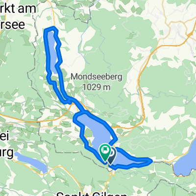
Mondsee+Irrsee körút
A cycling route starting in Sankt Lorenz, Upper Austria, Austria.
Overview
About this route
- -:--
- Duration
- 50.1 km
- Distance
- 733 m
- Ascent
- 710 m
- Descent
- ---
- Avg. speed
- 588 m
- Max. altitude

Continue with Bikemap
Use, edit, or download this cycling route
You would like to ride Mondsee+Irrsee körút or customize it for your own trip? Here is what you can do with this Bikemap route:
Free features
- Save this route as favorite or in collections
- Copy & plan your own version of this route
- Sync your route with Garmin or Wahoo
Premium features
Free trial for 3 days, or one-time payment. More about Bikemap Premium.
- Navigate this route on iOS & Android
- Export a GPX / KML file of this route
- Create your custom printout (try it for free)
- Download this route for offline navigation
Discover more Premium features.
Get Bikemap PremiumFrom our community
Other popular routes starting in Sankt Lorenz
 Sankt Lorenz Radfahren
- Distance
- 56.6 km
- Ascent
- 576 m
- Descent
- 566 m
- Location
- Sankt Lorenz, Upper Austria, Austria
 Okruh okolo Mondsee
- Distance
- 23.5 km
- Ascent
- 414 m
- Descent
- 411 m
- Location
- Sankt Lorenz, Upper Austria, Austria
 Mondseerunde
- Distance
- 32.9 km
- Ascent
- 1,043 m
- Descent
- 1,041 m
- Location
- Sankt Lorenz, Upper Austria, Austria
 Schafberg
- Distance
- 13.5 km
- Ascent
- 972 m
- Descent
- 971 m
- Location
- Sankt Lorenz, Upper Austria, Austria
 Schafbergrunde CLONED FROM ROUTE 648239
- Distance
- 34.7 km
- Ascent
- 1,185 m
- Descent
- 1,185 m
- Location
- Sankt Lorenz, Upper Austria, Austria
 Eisenauclimb-Schwarzensee-Wolfgangsee-St.Gilgen
- Distance
- 38.9 km
- Ascent
- 1,837 m
- Descent
- 1,815 m
- Location
- Sankt Lorenz, Upper Austria, Austria
 Mondsee+Irrsee körút
- Distance
- 50.1 km
- Ascent
- 733 m
- Descent
- 710 m
- Location
- Sankt Lorenz, Upper Austria, Austria
 okolo 3 jazier
- Distance
- 62 km
- Ascent
- 412 m
- Descent
- 412 m
- Location
- Sankt Lorenz, Upper Austria, Austria
Open it in the app