
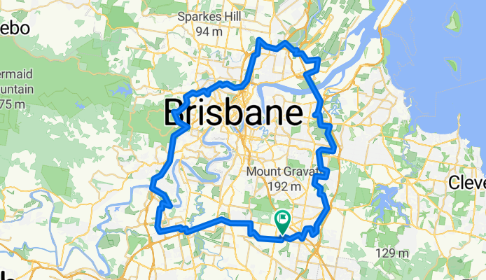
The long way around
A cycling route starting in Robertson, Queensland, Australia.
Overview
About this route
- 4 h 59 min
- Duration
- 85.9 km
- Distance
- 561 m
- Ascent
- 560 m
- Descent
- 17.2 km/h
- Avg. speed
- 89 m
- Max. altitude
Route quality
Waytypes & surfaces along the route
Waytypes
Cycleway
67 km
(78 %)
Quiet road
6.9 km
(8 %)
Surfaces
Paved
80.8 km
(94 %)
Concrete
60.2 km
(70 %)
Asphalt
19.8 km
(23 %)
Continue with Bikemap
Use, edit, or download this cycling route
You would like to ride The long way around or customize it for your own trip? Here is what you can do with this Bikemap route:
Free features
- Save this route as favorite or in collections
- Copy & plan your own version of this route
- Split it into stages to create a multi-day tour
- Sync your route with Garmin or Wahoo
Premium features
Free trial for 3 days, or one-time payment. More about Bikemap Premium.
- Navigate this route on iOS & Android
- Export a GPX / KML file of this route
- Create your custom printout (try it for free)
- Download this route for offline navigation
Discover more Premium features.
Get Bikemap PremiumFrom our community
Other popular routes starting in Robertson
 Relaxed route in South Brisbane
- Distance
- 14.3 km
- Ascent
- 128 m
- Descent
- 184 m
- Location
- Robertson, Queensland, Australia
 bunnying
- Distance
- 14.3 km
- Ascent
- 15 m
- Descent
- 31 m
- Location
- Robertson, Queensland, Australia
 4 Meta Street, Sunnybank to 1 Bengal Court, Carindale
- Distance
- 13.4 km
- Ascent
- 110 m
- Descent
- 153 m
- Location
- Robertson, Queensland, Australia
 Route to 479–491 Stanley St, South Brisbane
- Distance
- 11.4 km
- Ascent
- 148 m
- Descent
- 205 m
- Location
- Robertson, Queensland, Australia
 North South Loop
- Distance
- 22.8 km
- Ascent
- 144 m
- Descent
- 144 m
- Location
- Robertson, Queensland, Australia
 317 McCullough St, Sunnybank to 56–60 Regent St, Woolloongabba
- Distance
- 12.5 km
- Ascent
- 89 m
- Descent
- 135 m
- Location
- Robertson, Queensland, Australia
 57A Boorman St, Sunnybank to Surfers Paradise
- Distance
- 101.6 km
- Ascent
- 616 m
- Descent
- 672 m
- Location
- Robertson, Queensland, Australia
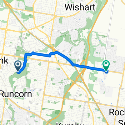 Dunedin Street, Sunnybank to Peregrine Street, Rochedale
- Distance
- 5.7 km
- Ascent
- 66 m
- Descent
- 63 m
- Location
- Robertson, Queensland, Australia
Open it in the app