![BikeMap[comute]](/_next/static/media/contour-lines-light-small.cafd5e5d.avif)
![BikeMap[comute]](https://media.bikemap.net/routes/17552678/staticmaps/in_be1791f0-97cd-4aa6-ace7-effad91838c9_694x400_bikemap-2021-3D-static.png)
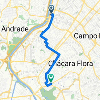
BikeMap[comute]
A cycling route starting in Taboão da Serra, São Paulo, Brazil.
Overview
About this route
- 15 min
- Duration
- 4.4 km
- Distance
- 33 m
- Ascent
- 92 m
- Descent
- 17.1 km/h
- Avg. speed
- 798 m
- Max. altitude

Route quality
Waytypes & surfaces along the route
Waytypes
Road
0.5 km
(11 %)
Quiet road
0.1 km
(3 %)
Undefined
3.8 km
(86 %)
Surfaces
Paved
1.4 km
(31 %)
Asphalt
1.4 km
(31 %)
Undefined
3 km
(69 %)
Continue with Bikemap
Use, edit, or download this cycling route
You would like to ride BikeMap[comute] or customize it for your own trip? Here is what you can do with this Bikemap route:
Free features
- Save this route as favorite or in collections
- Copy & plan your own version of this route
- Sync your route with Garmin or Wahoo
Premium features
Free trial for 3 days, or one-time payment. More about Bikemap Premium.
- Navigate this route on iOS & Android
- Export a GPX / KML file of this route
- Create your custom printout (try it for free)
- Download this route for offline navigation
Discover more Premium features.
Get Bikemap PremiumFrom our community
Other popular routes starting in Taboão da Serra
 Rua : próspero Cesarino paoliello
- Distance
- 8.2 km
- Ascent
- 110 m
- Descent
- 93 m
- Location
- Taboão da Serra, São Paulo, Brazil
 Rota de quinta rápida com subidas
- Distance
- 44.8 km
- Ascent
- 256 m
- Descent
- 257 m
- Location
- Taboão da Serra, São Paulo, Brazil
 De Avenida Guido Caloi 1300 a Avenida Professor Fonseca Rodrigues 2001
- Distance
- 22.5 km
- Ascent
- 224 m
- Descent
- 228 m
- Location
- Taboão da Serra, São Paulo, Brazil
 Casa Rápido
- Distance
- 7.3 km
- Ascent
- 80 m
- Descent
- 56 m
- Location
- Taboão da Serra, São Paulo, Brazil
 enferrujado
- Distance
- 43.1 km
- Ascent
- 226 m
- Descent
- 254 m
- Location
- Taboão da Serra, São Paulo, Brazil
 De Rua Carlos Magalhães a Rua Carlos Magalhães
- Distance
- 48.8 km
- Ascent
- 477 m
- Descent
- 470 m
- Location
- Taboão da Serra, São Paulo, Brazil
 Rodovia Régis Bittencourt, Taboão da Serra a Rua Cachoeirinha, Taboão da Serra
- Distance
- 23.5 km
- Ascent
- 276 m
- Descent
- 251 m
- Location
- Taboão da Serra, São Paulo, Brazil
 Rota para Avenida Eliseu de Almeida
- Distance
- 22.9 km
- Ascent
- 1,473 m
- Descent
- 1,545 m
- Location
- Taboão da Serra, São Paulo, Brazil
Open it in the app