
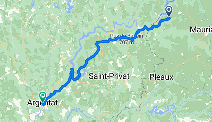
Etape 1 : DORDOGNE Chalvignac to Argentat-sur-Dordogne
A cycling route starting in Mauriac, Auvergne-Rhône-Alpes, France.
Overview
About this route
- 2 h 56 min
- Duration
- 45.8 km
- Distance
- 1,069 m
- Ascent
- 1,393 m
- Descent
- 15.6 km/h
- Avg. speed
- 606 m
- Max. altitude
Route quality
Waytypes & surfaces along the route
Waytypes
Road
22.9 km
(50 %)
Quiet road
11.4 km
(25 %)
Surfaces
Paved
2.7 km
(6 %)
Asphalt
2.7 km
(6 %)
Undefined
43 km
(94 %)
Continue with Bikemap
Use, edit, or download this cycling route
You would like to ride Etape 1 : DORDOGNE Chalvignac to Argentat-sur-Dordogne or customize it for your own trip? Here is what you can do with this Bikemap route:
Free features
- Save this route as favorite or in collections
- Copy & plan your own version of this route
- Sync your route with Garmin or Wahoo
Premium features
Free trial for 3 days, or one-time payment. More about Bikemap Premium.
- Navigate this route on iOS & Android
- Export a GPX / KML file of this route
- Create your custom printout (try it for free)
- Download this route for offline navigation
Discover more Premium features.
Get Bikemap PremiumFrom our community
Other popular routes starting in Mauriac
 Dauphine 2
- Distance
- 178.9 km
- Ascent
- 2,354 m
- Descent
- 2,165 m
- Location
- Mauriac, Auvergne-Rhône-Alpes, France
 Gentiane 30 Km
- Distance
- 28.8 km
- Ascent
- 380 m
- Descent
- 380 m
- Location
- Mauriac, Auvergne-Rhône-Alpes, France
 Gentiane 103 Km
- Distance
- 102 km
- Ascent
- 1,508 m
- Descent
- 1,508 m
- Location
- Mauriac, Auvergne-Rhône-Alpes, France
 Gentiane 75 Km
- Distance
- 75 km
- Ascent
- 1,136 m
- Descent
- 1,136 m
- Location
- Mauriac, Auvergne-Rhône-Alpes, France
 Mauriac - Estaing
- Distance
- 178 km
- Ascent
- 3,198 m
- Descent
- 3,595 m
- Location
- Mauriac, Auvergne-Rhône-Alpes, France
 R-C pro2 J2 - Moussages - Les étangs
- Distance
- 36.9 km
- Ascent
- 509 m
- Descent
- 558 m
- Location
- Mauriac, Auvergne-Rhône-Alpes, France
 Chalvignac - Nau
- Distance
- 18.3 km
- Ascent
- 492 m
- Descent
- 489 m
- Location
- Mauriac, Auvergne-Rhône-Alpes, France
 R-C J2 pro1 - Moussages - Champs/Tarentaine
- Distance
- 30.1 km
- Ascent
- 260 m
- Descent
- 602 m
- Location
- Mauriac, Auvergne-Rhône-Alpes, France
Open it in the app