
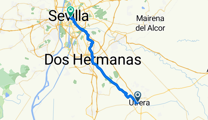
etappe 4: van Utrera naar Sevilla
A cycling route starting in Utrera, Andalusia, Spain.
Overview
About this route
Embark on an invigorating cycling adventure through Seville, starting at the charming Hotel Veracruz. Covering 37.5 km, this route takes you on a journey with an elevation gain of 140 meters and a gentle descent of 167 meters. The route ascends to its highest point at 79 meters.
The terrain is a delightful mix of surfaces, predominantly featuring asphalt at 6164 meters, which makes up 16.4% of the journey. You'll also encounter sections on paved paths, adding a smooth touch to your ride. Additionally, a significant portion of the route, 21677 meters, is on undefined surfaces, offering a bit of variety.
Throughout your ride, enjoy the scenic beauty of Cycleways, Quiet Roads, and Tracks, making this route a harmonious blend of nature and infrastructure. The bike network supports your journey, with 96% of the route being part of the undefined network. Paved sections are abundant, contributing to a comfortable and steady pace.
This route is perfect for cycling enthusiasts seeking a blend of adventure and tranquility, showcasing the best of Seville's landscapes and infrastructure.
AI generated
- 2 h 21 min
- Duration
- 37.5 km
- Distance
- 140 m
- Ascent
- 167 m
- Descent
- 15.9 km/h
- Avg. speed
- 80 m
- Max. altitude
Route quality
Waytypes & surfaces along the route
Waytypes
Cycleway
14.6 km
(39 %)
Quiet road
13.5 km
(36 %)
Surfaces
Paved
11.6 km
(31 %)
Unpaved
3.7 km
(10 %)
Asphalt
6 km
(16 %)
Paved (undefined)
5.2 km
(14 %)
Continue with Bikemap
Use, edit, or download this cycling route
You would like to ride etappe 4: van Utrera naar Sevilla or customize it for your own trip? Here is what you can do with this Bikemap route:
Free features
- Save this route as favorite or in collections
- Copy & plan your own version of this route
- Sync your route with Garmin or Wahoo
Premium features
Free trial for 3 days, or one-time payment. More about Bikemap Premium.
- Navigate this route on iOS & Android
- Export a GPX / KML file of this route
- Create your custom printout (try it for free)
- Download this route for offline navigation
Discover more Premium features.
Get Bikemap PremiumFrom our community
Other popular routes starting in Utrera
 UTRERA-MARIBAÑEZ-LOSPALACIOS-UTRERA
- Distance
- 44.3 km
- Ascent
- 96 m
- Descent
- 90 m
- Location
- Utrera, Andalusia, Spain
 Utrera to Surya
- Distance
- 64.2 km
- Ascent
- 541 m
- Descent
- 437 m
- Location
- Utrera, Andalusia, Spain
 Utrera to Surya (2)
- Distance
- 64.4 km
- Ascent
- 838 m
- Descent
- 733 m
- Location
- Utrera, Andalusia, Spain
 Utrera_Montellano_Salado_Utrera
- Distance
- 75.8 km
- Ascent
- 535 m
- Descent
- 530 m
- Location
- Utrera, Andalusia, Spain
 Utrera - Arahal
- Distance
- 49.8 km
- Ascent
- 124 m
- Descent
- 126 m
- Location
- Utrera, Andalusia, Spain
 Utrera-Laguna Zarracatin-Utrera
- Distance
- 50.1 km
- Ascent
- 323 m
- Descent
- 323 m
- Location
- Utrera, Andalusia, Spain
 EL CORONIL - PANTANO TORRE DEL ÁGUILA
- Distance
- 43.3 km
- Ascent
- 362 m
- Descent
- 365 m
- Location
- Utrera, Andalusia, Spain
 UTRERA - EMBARCADERO DE CORIA
- Distance
- 72.6 km
- Ascent
- 105 m
- Descent
- 103 m
- Location
- Utrera, Andalusia, Spain
Open it in the app