
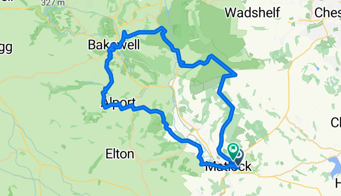
Hurst Rise 55C to Springfield Rise
A cycling route starting in Matlock, England, United Kingdom.
Overview
About this route
- 2 h 41 min
- Duration
- 41.8 km
- Distance
- 941 m
- Ascent
- 920 m
- Descent
- 15.6 km/h
- Avg. speed
- 341 m
- Max. altitude

Route quality
Waytypes & surfaces along the route
Waytypes
Quiet road
25.1 km
(60 %)
Road
10.9 km
(26 %)
Surfaces
Paved
9.6 km
(23 %)
Unpaved
1.3 km
(3 %)
Asphalt
8.8 km
(21 %)
Gravel
1.3 km
(3 %)
Continue with Bikemap
Use, edit, or download this cycling route
You would like to ride Hurst Rise 55C to Springfield Rise or customize it for your own trip? Here is what you can do with this Bikemap route:
Free features
- Save this route as favorite or in collections
- Copy & plan your own version of this route
- Sync your route with Garmin or Wahoo
Premium features
Free trial for 3 days, or one-time payment. More about Bikemap Premium.
- Navigate this route on iOS & Android
- Export a GPX / KML file of this route
- Create your custom printout (try it for free)
- Download this route for offline navigation
Discover more Premium features.
Get Bikemap PremiumFrom our community
Other popular routes starting in Matlock
 New Way of the Rings Matlock to Derby
- Distance
- 42.2 km
- Ascent
- 447 m
- Descent
- 554 m
- Location
- Matlock, England, United Kingdom
 Bakewell, Alport
- Distance
- 22.3 km
- Ascent
- 329 m
- Descent
- 329 m
- Location
- Matlock, England, United Kingdom
 Midlands Hills
- Distance
- 114.2 km
- Ascent
- 1,367 m
- Descent
- 1,367 m
- Location
- Matlock, England, United Kingdom
 Hurst Rise 55C to Springfield Rise
- Distance
- 41.8 km
- Ascent
- 941 m
- Descent
- 920 m
- Location
- Matlock, England, United Kingdom
 Matlock Triathlon
- Distance
- 16.1 km
- Ascent
- 296 m
- Descent
- 294 m
- Location
- Matlock, England, United Kingdom
 Midlands Hills #2
- Distance
- 188 km
- Ascent
- 2,164 m
- Descent
- 2,164 m
- Location
- Matlock, England, United Kingdom
 Birchover to Stanton
- Distance
- 15.7 km
- Ascent
- 271 m
- Descent
- 271 m
- Location
- Matlock, England, United Kingdom
 Midlands Hills
- Distance
- 113.2 km
- Ascent
- 1,324 m
- Descent
- 1,324 m
- Location
- Matlock, England, United Kingdom
Open it in the app