
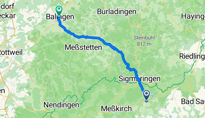
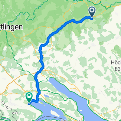
Hauptstraße, Krauchenwies nach Bahnhofstraße, Balingen
A cycling route starting in Krauchenwies, Baden-Wurttemberg, Germany.
Overview
About this route
- 3 h 10 min
- Duration
- 53.2 km
- Distance
- 657 m
- Ascent
- 721 m
- Descent
- 16.8 km/h
- Avg. speed
- 817 m
- Max. altitude

Route quality
Waytypes & surfaces along the route
Waytypes
Quiet road
23.9 km
(45 %)
Track
17 km
(32 %)
Surfaces
Paved
46.3 km
(87 %)
Unpaved
4.3 km
(8 %)
Asphalt
44.7 km
(84 %)
Paved (undefined)
1.6 km
(3 %)
Continue with Bikemap
Use, edit, or download this cycling route
You would like to ride Hauptstraße, Krauchenwies nach Bahnhofstraße, Balingen or customize it for your own trip? Here is what you can do with this Bikemap route:
Free features
- Save this route as favorite or in collections
- Copy & plan your own version of this route
- Sync your route with Garmin or Wahoo
Premium features
Free trial for 3 days, or one-time payment. More about Bikemap Premium.
- Navigate this route on iOS & Android
- Export a GPX / KML file of this route
- Create your custom printout (try it for free)
- Download this route for offline navigation
Discover more Premium features.
Get Bikemap PremiumFrom our community
Other popular routes starting in Krauchenwies
 Hauptstraße, Krauchenwies nach Hauptstraße, Krauchenwies
- Distance
- 43.3 km
- Ascent
- 314 m
- Descent
- 317 m
- Location
- Krauchenwies, Baden-Wurttemberg, Germany
 Hauptstraße, Krauchenwies nach Hegaustraße, Moos
- Distance
- 59.8 km
- Ascent
- 464 m
- Descent
- 636 m
- Location
- Krauchenwies, Baden-Wurttemberg, Germany
 Hauptstraße, Krauchenwies nach Bahnhofstraße, Balingen
- Distance
- 53.2 km
- Ascent
- 657 m
- Descent
- 721 m
- Location
- Krauchenwies, Baden-Wurttemberg, Germany
 Krauchenwies - Neunkirch
- Distance
- 88.8 km
- Ascent
- 873 m
- Descent
- 1,029 m
- Location
- Krauchenwies, Baden-Wurttemberg, Germany
 Hauptstraße, Krauchenwies nach Radolfzeller Straße, Moos
- Distance
- 57.1 km
- Ascent
- 440 m
- Descent
- 629 m
- Location
- Krauchenwies, Baden-Wurttemberg, Germany
 Hauptstraße, Krauchenwies nach Rue de la Paix, Thonon-les-Bains
- Distance
- 395.2 km
- Ascent
- 3,981 m
- Descent
- 4,142 m
- Location
- Krauchenwies, Baden-Wurttemberg, Germany
 30km Tour
- Distance
- 30 km
- Ascent
- 301 m
- Descent
- 301 m
- Location
- Krauchenwies, Baden-Wurttemberg, Germany
 Hauptstraße, Krauchenwies nach Am Lindle, Balingen
- Distance
- 55.6 km
- Ascent
- 744 m
- Descent
- 819 m
- Location
- Krauchenwies, Baden-Wurttemberg, Germany
Open it in the app