
mom & dad bound
A cycling route starting in Dreieich, Hesse, Germany.
Overview
About this route
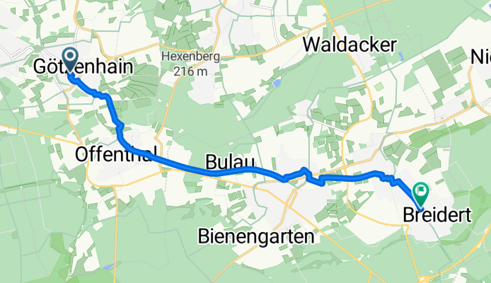
Embark on a scenic 10.5 km cycling adventure that takes you from Goethering 32 in Dreieich to Somborer Straße in Rödermark. This route offers a gentle climb with an elevation gain of just 22 meters, balanced by a descent of 63 meters, reaching a maximum elevation of 195 meters.
The journey predominantly features smooth asphalt surfaces, covering 9442 meters of your ride, which makes up 89.9% of your route. You'll also encounter stretches of paved paths, with 9718 meters being well-maintained, accounting for 92.5% of your ride.
The route is a mix of serene forest paths (5575 meters, 53.1%) and calm country lanes (4023 meters, 38.3%), providing a tranquil cycling experience through diverse landscapes.
With a significant portion of your ride on the Regional cycling network (6549 meters, 62.4%) and some undefined paths (2959 meters, 28.2%), this route offers a blend of well-trodden and lesser-known cycling routes.
AI generated
- 36 min
- Duration
- 10.5 km
- Distance
- 23 m
- Ascent
- 64 m
- Descent
- 17.6 km/h
- Avg. speed
- 196 m
- Max. altitude
Route quality
Waytypes & surfaces along the route
Waytypes
Track
5.6 km
(53 %)
Quiet road
3.9 km
(37 %)
Surfaces
Paved
9.7 km
(92 %)
Asphalt
9.5 km
(90 %)
Paved (undefined)
0.1 km
(1 %)
Continue with Bikemap
Use, edit, or download this cycling route
You would like to ride mom & dad bound or customize it for your own trip? Here is what you can do with this Bikemap route:
Free features
- Save this route as favorite or in collections
- Copy & plan your own version of this route
- Sync your route with Garmin or Wahoo
Premium features
Free trial for 3 days, or one-time payment. More about Bikemap Premium.
- Navigate this route on iOS & Android
- Export a GPX / KML file of this route
- Create your custom printout (try it for free)
- Download this route for offline navigation
Discover more Premium features.
Get Bikemap PremiumFrom our community
Other popular routes starting in Dreieich
 Trials around Dreieich
- Distance
- 28 km
- Ascent
- 133 m
- Descent
- 112 m
- Location
- Dreieich, Hesse, Germany
 Landsteinerstraße nach Bahnstraße
- Distance
- 18.9 km
- Ascent
- 101 m
- Descent
- 181 m
- Location
- Dreieich, Hesse, Germany
 An der Trift, Dreieich nach Im Herrngarten, Heusenstamm
- Distance
- 13.3 km
- Ascent
- 37 m
- Descent
- 66 m
- Location
- Dreieich, Hesse, Germany
 Single Trail an der A 661 am Dreieichenhainer Industriegebiet
- Distance
- 0.7 km
- Ascent
- 10 m
- Descent
- 0 m
- Location
- Dreieich, Hesse, Germany
 Dreieich - Heidelberg
- Distance
- 82.8 km
- Ascent
- 364 m
- Descent
- 386 m
- Location
- Dreieich, Hesse, Germany
 Riedl Ranche/BulauNaturfreundehaus
- Distance
- 18.2 km
- Ascent
- 115 m
- Descent
- 115 m
- Location
- Dreieich, Hesse, Germany
 Landsteinerstraße nach Landsteinerstraße
- Distance
- 10.5 km
- Ascent
- 58 m
- Descent
- 101 m
- Location
- Dreieich, Hesse, Germany
 An der Trift nach Landsteinerstraße
- Distance
- 10.4 km
- Ascent
- 75 m
- Descent
- 120 m
- Location
- Dreieich, Hesse, Germany
Open it in the app