
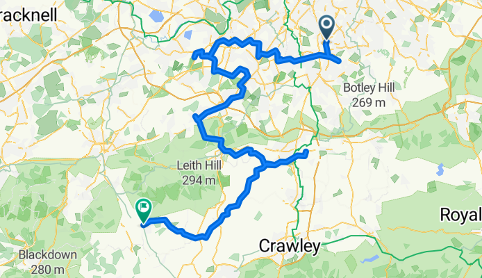
From Croydon to Cranleigh
A cycling route starting in Croydon, England, United Kingdom.
Overview
About this route
Day 1 of Tour De Lodges
- 7 h 19 min
- Duration
- 122.6 km
- Distance
- 924 m
- Ascent
- 923 m
- Descent
- 16.7 km/h
- Avg. speed
- 141 m
- Max. altitude
Route quality
Waytypes & surfaces along the route
Waytypes
Quiet road
53.9 km
(44 %)
Road
38 km
(31 %)
Surfaces
Paved
58.8 km
(48 %)
Unpaved
3.7 km
(3 %)
Asphalt
58.8 km
(48 %)
Unpaved (undefined)
1.2 km
(1 %)
Continue with Bikemap
Use, edit, or download this cycling route
You would like to ride From Croydon to Cranleigh or customize it for your own trip? Here is what you can do with this Bikemap route:
Free features
- Save this route as favorite or in collections
- Copy & plan your own version of this route
- Split it into stages to create a multi-day tour
- Sync your route with Garmin or Wahoo
Premium features
Free trial for 3 days, or one-time payment. More about Bikemap Premium.
- Navigate this route on iOS & Android
- Export a GPX / KML file of this route
- Create your custom printout (try it for free)
- Download this route for offline navigation
Discover more Premium features.
Get Bikemap PremiumFrom our community
Other popular routes starting in Croydon
 First Ride - Loop v2
- Distance
- 39 km
- Ascent
- 444 m
- Descent
- 444 m
- Location
- Croydon, England, United Kingdom
 From Croydon to Cranleigh
- Distance
- 122.6 km
- Ascent
- 924 m
- Descent
- 923 m
- Location
- Croydon, England, United Kingdom
 MTB-Biggin Hill from East Croydon
- Distance
- 48.6 km
- Ascent
- 580 m
- Descent
- 580 m
- Location
- Croydon, England, United Kingdom
 Croydon - Forest Row
- Distance
- 45.4 km
- Ascent
- 0 m
- Descent
- 0 m
- Location
- Croydon, England, United Kingdom
 Croydon, Croydon to Cycleway Six, London
- Distance
- 19.9 km
- Ascent
- 113 m
- Descent
- 160 m
- Location
- Croydon, England, United Kingdom
 4 Parks in Croydon
- Distance
- 18.9 km
- Ascent
- 134 m
- Descent
- 133 m
- Location
- Croydon, England, United Kingdom
 Vanguard Way - Vanguard Way on AllTrails
- Distance
- 108 km
- Ascent
- 0 m
- Descent
- 0 m
- Location
- Croydon, England, United Kingdom
 Croydon, Layhams Road, Botley, Redhill, Dorking, Box HIll loop
- Distance
- 83.4 km
- Ascent
- 638 m
- Descent
- 639 m
- Location
- Croydon, England, United Kingdom
Open it in the app