

AUT Aineck trip
A cycling route starting in Mariapfarr, Salzburg, Austria.
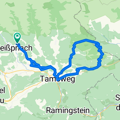
Overview
About this route
Impressive and challanging trip, climb to Aineck hardly drivable
- -:--
- Duration
- 51.1 km
- Distance
- 1,411 m
- Ascent
- 1,411 m
- Descent
- ---
- Avg. speed
- ---
- Max. altitude
Continue with Bikemap
Use, edit, or download this cycling route
You would like to ride AUT Aineck trip or customize it for your own trip? Here is what you can do with this Bikemap route:
Free features
- Save this route as favorite or in collections
- Copy & plan your own version of this route
- Sync your route with Garmin or Wahoo
Premium features
Free trial for 3 days, or one-time payment. More about Bikemap Premium.
- Navigate this route on iOS & Android
- Export a GPX / KML file of this route
- Create your custom printout (try it for free)
- Download this route for offline navigation
Discover more Premium features.
Get Bikemap PremiumFrom our community
Other popular routes starting in Mariapfarr
 Morgenrunde
- Distance
- 5.8 km
- Ascent
- 115 m
- Descent
- 118 m
- Location
- Mariapfarr, Salzburg, Austria
 Warm - UP
- Distance
- 33.1 km
- Ascent
- 303 m
- Descent
- 301 m
- Location
- Mariapfarr, Salzburg, Austria
 AUT Wildbachutte
- Distance
- 34.1 km
- Ascent
- 900 m
- Descent
- 900 m
- Location
- Mariapfarr, Salzburg, Austria
 18 GH Lackner-Vorderdorf-Wildbachhütte
- Distance
- 16.5 km
- Ascent
- 737 m
- Descent
- 737 m
- Location
- Mariapfarr, Salzburg, Austria
 AUT Wildbachutte
- Distance
- 34.1 km
- Ascent
- 859 m
- Descent
- 858 m
- Location
- Mariapfarr, Salzburg, Austria
 Göriach - Landawirseehütte - Trockenbrotscharte
- Distance
- 28.4 km
- Ascent
- 1,036 m
- Descent
- 1,036 m
- Location
- Mariapfarr, Salzburg, Austria
 Longa
Longa- Distance
- 10 km
- Ascent
- 287 m
- Descent
- 64 m
- Location
- Mariapfarr, Salzburg, Austria
 2010_07_26_Preberseerunde
- Distance
- 54.9 km
- Ascent
- 1,195 m
- Descent
- 1,216 m
- Location
- Mariapfarr, Salzburg, Austria
Open it in the app