
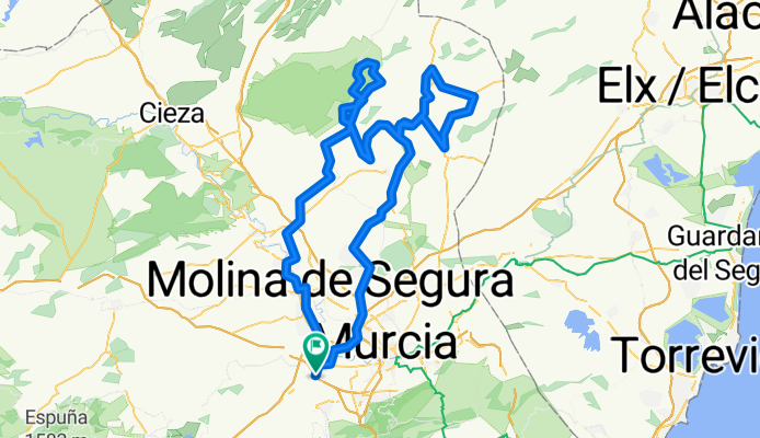
Sierra de la Pila
A cycling route starting in Alcantarilla, Murcia, Spain.
Overview
About this route
Sierra de la Pila
- -:--
- Duration
- 154.9 km
- Distance
- 1,373 m
- Ascent
- 1,375 m
- Descent
- ---
- Avg. speed
- ---
- Avg. speed

Route quality
Waytypes & surfaces along the route
Waytypes
Busy road
72.8 km
(47 %)
Quiet road
46.3 km
(30 %)
Surfaces
Paved
75.9 km
(49 %)
Unpaved
2.5 km
(2 %)
Asphalt
75 km
(48 %)
Gravel
2.2 km
(1 %)
Route highlights
Points of interest along the route
Point of interest after 104.5 km
Continue with Bikemap
Use, edit, or download this cycling route
You would like to ride Sierra de la Pila or customize it for your own trip? Here is what you can do with this Bikemap route:
Free features
- Save this route as favorite or in collections
- Copy & plan your own version of this route
- Sync your route with Garmin or Wahoo
Premium features
Free trial for 3 days, or one-time payment. More about Bikemap Premium.
- Navigate this route on iOS & Android
- Export a GPX / KML file of this route
- Create your custom printout (try it for free)
- Download this route for offline navigation
Discover more Premium features.
Get Bikemap PremiumFrom our community
Other popular routes starting in Alcantarilla
 INTEGRAL DE LA CABRA 2010
- Distance
- 69.7 km
- Ascent
- 1,301 m
- Descent
- 1,304 m
- Location
- Alcantarilla, Murcia, Spain
 Salida dia 01/02/14
- Distance
- 118.2 km
- Ascent
- 841 m
- Descent
- 842 m
- Location
- Alcantarilla, Murcia, Spain
 Salida dia 22/02/14
- Distance
- 106 km
- Ascent
- 364 m
- Descent
- 367 m
- Location
- Alcantarilla, Murcia, Spain
 Salida 15/03/14
- Distance
- 92.6 km
- Ascent
- 602 m
- Descent
- 605 m
- Location
- Alcantarilla, Murcia, Spain
 Salida 25/01/14
- Distance
- 69.4 km
- Ascent
- 495 m
- Descent
- 499 m
- Location
- Alcantarilla, Murcia, Spain
 A LA PINILLA POR TOTANA -EL PARETON- Y VUELTA POR LAS CUEVAS DEL REYLLO
- Distance
- 128.8 km
- Ascent
- 572 m
- Descent
- 587 m
- Location
- Alcantarilla, Murcia, Spain
 A YECHAR POR ALHAMA-EL NIÑO
- Distance
- 115.9 km
- Ascent
- 940 m
- Descent
- 931 m
- Location
- Alcantarilla, Murcia, Spain
 ZARZADILLA DE TOTANA POR CARIVETE Y CEMENTERA
- Distance
- 170 km
- Ascent
- 1,122 m
- Descent
- 1,125 m
- Location
- Alcantarilla, Murcia, Spain
Open it in the app