
Nach Nußdorf
A cycling route starting in Vienna, Vienna, Austria.
Overview
About this route
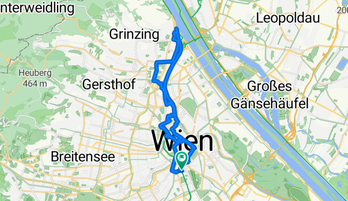
Karlsplatz - Albertina - Altes Rathaus - Donaukanal - Nordbahnhof - Wertheimsetinpark - Muthgasse - Einlaufbauwerk - Donaukanal - Servitenviertel - Berggasse - Votivkirche - Mölker Bastei - Tuchlauben - Anker Uhr - Bäckerstraße - Alte Uni - Parkring - Konzerthaus - Karlsplatz
- -:--
- Duration
- 20.6 km
- Distance
- 141 m
- Ascent
- 141 m
- Descent
- ---
- Avg. speed
- ---
- Avg. speed
Route quality
Waytypes & surfaces along the route
Waytypes
Quiet road
7.2 km
(35 %)
Cycleway
6.2 km
(30 %)
Surfaces
Paved
20.1 km
(98 %)
Asphalt
18.1 km
(88 %)
Paving stones
1 km
(5 %)
Route highlights
Points of interest along the route

Point of interest after 2.5 km
Altes Rathaus

Point of interest after 3.1 km
Börse

Point of interest after 10.2 km
Beginn Donaukanal

Point of interest after 14.9 km
Serviten Kirche

Point of interest after 15.9 km
Votivkirche

Point of interest after 16.8 km
Mölkerbastei

Point of interest after 18.1 km
Anker Uhr

Point of interest after 18.6 km
Alte Uni
Continue with Bikemap
Use, edit, or download this cycling route
You would like to ride Nach Nußdorf or customize it for your own trip? Here is what you can do with this Bikemap route:
Free features
- Save this route as favorite or in collections
- Copy & plan your own version of this route
- Sync your route with Garmin or Wahoo
Premium features
Free trial for 3 days, or one-time payment. More about Bikemap Premium.
- Navigate this route on iOS & Android
- Export a GPX / KML file of this route
- Create your custom printout (try it for free)
- Download this route for offline navigation
Discover more Premium features.
Get Bikemap PremiumFrom our community
Other popular routes starting in Vienna
 Tour de Vienna
- Distance
- 22 km
- Ascent
- 105 m
- Descent
- 104 m
- Location
- Vienna, Vienna, Austria
 Donau-Radweg: Wien-Bratislava
- Distance
- 70.9 km
- Ascent
- 332 m
- Descent
- 340 m
- Location
- Vienna, Vienna, Austria
 Wien - Haslau an der Donau - Kittsee - Wien
- Distance
- 138.3 km
- Ascent
- 371 m
- Descent
- 423 m
- Location
- Vienna, Vienna, Austria
 After_Work_Training_Standard
- Distance
- 69.7 km
- Ascent
- 1,149 m
- Descent
- 1,084 m
- Location
- Vienna, Vienna, Austria
 Augustiner- u Mostalmtrail über Sophienalpe
- Distance
- 32.1 km
- Ascent
- 540 m
- Descent
- 534 m
- Location
- Vienna, Vienna, Austria
 Boku-Exelberg-Sophie-Riederb-TulbingK-Königstetten-St-Andrae-Hintersd-Boku
- Distance
- 84.2 km
- Ascent
- 1,189 m
- Descent
- 1,189 m
- Location
- Vienna, Vienna, Austria
 Eduard-Sueß-Gasse 24–30, Wien nach Eduard-Sueß-Gasse 26, Wien
- Distance
- 38.8 km
- Ascent
- 194 m
- Descent
- 191 m
- Location
- Vienna, Vienna, Austria
 Summer Event
- Distance
- 31.4 km
- Ascent
- 186 m
- Descent
- 185 m
- Location
- Vienna, Vienna, Austria
Open it in the app