
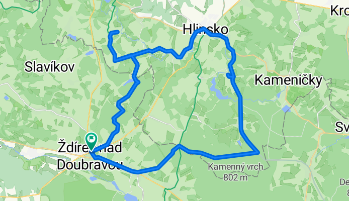
Na Veselý Kopec a přes Hlinsko zpět
A cycling route starting in Krucemburk, Kraj Vysočina, Czechia.
Overview
About this route
To Joyful Hill and back via Hlinsko
- -:--
- Duration
- 40.3 km
- Distance
- 356 m
- Ascent
- 356 m
- Descent
- ---
- Avg. speed
- ---
- Max. altitude
Route quality
Waytypes & surfaces along the route
Waytypes
Road
16.5 km
(41 %)
Track
9.7 km
(24 %)
Surfaces
Paved
20.6 km
(51 %)
Unpaved
4.4 km
(11 %)
Asphalt
20.6 km
(51 %)
Unpaved (undefined)
4 km
(10 %)
Continue with Bikemap
Use, edit, or download this cycling route
You would like to ride Na Veselý Kopec a přes Hlinsko zpět or customize it for your own trip? Here is what you can do with this Bikemap route:
Free features
- Save this route as favorite or in collections
- Copy & plan your own version of this route
- Sync your route with Garmin or Wahoo
Premium features
Free trial for 3 days, or one-time payment. More about Bikemap Premium.
- Navigate this route on iOS & Android
- Export a GPX / KML file of this route
- Create your custom printout (try it for free)
- Download this route for offline navigation
Discover more Premium features.
Get Bikemap PremiumFrom our community
Other popular routes starting in Krucemburk
 Třemošnice tam a zpět
- Distance
- 62.1 km
- Ascent
- 474 m
- Descent
- 514 m
- Location
- Krucemburk, Kraj Vysočina, Czechia
 2012 06 13 Křížem krážem lesem nad Řekou
- Distance
- 24.9 km
- Ascent
- 209 m
- Descent
- 209 m
- Location
- Krucemburk, Kraj Vysočina, Czechia
 2017-08-05 Řeka - lesem na Ranská jezírka-po modré Sobíńov-Bílek- dolní Sokolovec-Sloupno- Slavíkov-Možděnice-zubří- TK-Petrkov- Veselý k. Januš-Kohoutov
- Distance
- 56.1 km
- Ascent
- 548 m
- Descent
- 550 m
- Location
- Krucemburk, Kraj Vysočina, Czechia
 Ransko, Losenica, Kameničky, Ransko
- Distance
- 63.8 km
- Ascent
- 534 m
- Descent
- 534 m
- Location
- Krucemburk, Kraj Vysočina, Czechia
 DoMi 1
- Distance
- 35.2 km
- Ascent
- 304 m
- Descent
- 307 m
- Location
- Krucemburk, Kraj Vysočina, Czechia
 2017-08-06 Řeka- Kohoutov-Stružinec- Údavy-Rovný- Podmokl-Štěpánov- po žluté- Bílek- Řeka
- Distance
- 33 km
- Ascent
- 328 m
- Descent
- 331 m
- Location
- Krucemburk, Kraj Vysočina, Czechia
 Ždírec nad Doubravou - Žďár nad Sázavou, pěšky
- Distance
- 21.9 km
- Ascent
- 263 m
- Descent
- 249 m
- Location
- Krucemburk, Kraj Vysočina, Czechia
 Oudolení No 1.
- Distance
- 76 km
- Ascent
- 571 m
- Descent
- 571 m
- Location
- Krucemburk, Kraj Vysočina, Czechia
Open it in the app