

15.07.05 Lechradweg
A cycling route starting in Steeg, Tyrol, Austria.
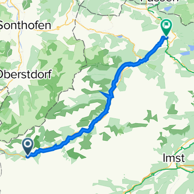
Overview
About this route
Nahezu nur bergab auf guten Wegen. Wunderschön zu fahren.
- -:--
- Duration
- 53.7 km
- Distance
- 52 m
- Ascent
- 313 m
- Descent
- ---
- Avg. speed
- ---
- Avg. speed

Route quality
Waytypes & surfaces along the route
Waytypes
Track
34.2 km
(64 %)
Quiet road
8.1 km
(15 %)
Surfaces
Paved
42.5 km
(79 %)
Unpaved
6.3 km
(12 %)
Asphalt
33.5 km
(62 %)
Paved (undefined)
8.7 km
(16 %)
Route highlights
Points of interest along the route
Accommodation after 26.3 km
Cafepause
Continue with Bikemap
Use, edit, or download this cycling route
You would like to ride 15.07.05 Lechradweg or customize it for your own trip? Here is what you can do with this Bikemap route:
Free features
- Save this route as favorite or in collections
- Copy & plan your own version of this route
- Sync your route with Garmin or Wahoo
Premium features
Free trial for 3 days, or one-time payment. More about Bikemap Premium.
- Navigate this route on iOS & Android
- Export a GPX / KML file of this route
- Create your custom printout (try it for free)
- Download this route for offline navigation
Discover more Premium features.
Get Bikemap PremiumFrom our community
Other popular routes starting in Steeg
 Steg - Pflach
- Distance
- 55.1 km
- Ascent
- 24 m
- Descent
- 308 m
- Location
- Steeg, Tyrol, Austria
 Steeg 23, Steeg nach Mühler Straße 1, Reutte
- Distance
- 52.7 km
- Ascent
- 420 m
- Descent
- 680 m
- Location
- Steeg, Tyrol, Austria
 Lechtal - Inntal
- Distance
- 79.6 km
- Ascent
- 1,737 m
- Descent
- 1,984 m
- Location
- Steeg, Tyrol, Austria
 Lechtal
- Distance
- 65.5 km
- Ascent
- 79 m
- Descent
- 393 m
- Location
- Steeg, Tyrol, Austria
 Steeg - Elbigenalp
- Distance
- 14.9 km
- Ascent
- 51 m
- Descent
- 110 m
- Location
- Steeg, Tyrol, Austria
 Lechtalradweg
- Distance
- 48.9 km
- Ascent
- 92 m
- Descent
- 352 m
- Location
- Steeg, Tyrol, Austria
 Almajurtal-Erlacher Hütte
- Distance
- 31 km
- Ascent
- 857 m
- Descent
- 857 m
- Location
- Steeg, Tyrol, Austria
 Steeg-Krabachtal
- Distance
- 10.1 km
- Ascent
- 771 m
- Descent
- 124 m
- Location
- Steeg, Tyrol, Austria
Open it in the app